Itanhém geodata
Itanhém (Bahia) is a populated place; located in Brazil in America/Bahia (GMT-3) time zone. With population of 13,517 people, there are 1329 cities with bigger population in this country. Compared to other cities in Brazil, 50.7% of cities are located further ↓South; 73.7% of cities are located further ←West and 62.4% of cities have higher elevation than Itanhém. Note1


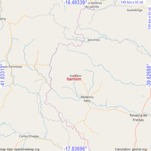
Itanhém GPS coordinates[2]
17° 9' 59.004" South, 40° 19' 48" West
| Map corner | latitude | longitude |
|---|---|---|
| Upper-left | -16.49339°, | -41.03313° |
| Center: | -17.16639°, | -40.33° |
| Lower-right: | -17.83696°, | -39.62688° |
| Map W x H: | 149.4×149.4 km | = 92.8×92.8mi |
| max Lat: | 2.81972° ⇑49.3% North |
| Itanhém: | -17.16639° |
| min Lat: | ⇓50.7% South -33.69111° |
| min Long | Itanhém | max Long |
| -72.89583° | -40.33° | -32.41083° |
| W 73.7%⇐ | ⇒26.3% E |
Elevation
Elevation of Itanhém is 189 m = 620 ft, and this is 191.9 m = 630 ft below average elevation for this country.
| Max E: |
1603 m = 5259 ft | 62.4% |
| Avg. | 380.9 m = 1250 ft | |
| Itanhém | 189 m = 620 ft | |
Min E: |
0 m = 0 ft | 37.6% |
See also: Brazil elevation on elevation.city.
Geographical zone
Itanhém is located in South Torrid zone (between Equator and Tropic of Capricorn). Distance of this Southern Tropic circle is 697.2 km =433.2 mi to South.| Distance of | km | miles | from Itanhém |
|---|---|---|---|
| Equator | 1908.7 | 1186 | to North |
| Tropic Capricorn | 697.2 | 433.2 | to South |
| Antarctic Circle | 5492.5 | 3412.9 | to South |
| South Pole | 8098.3 | 5032 | to South |


Nearby cities:
15 places around Itanhém: (largest is in red/bold)
• Almenara
116 km =72.1 mi,  340°
340°
• Carlos Chagas
75.5 km =46.9 mi,  217°
217°
• Eunápolis
118.6 km =73.7 mi,  42°
42°
• Guaratinga
87 km =54.1 mi, 42°
• Itamaraju
86.1 km =53.5 mi,  80°
80°
• Jequitinhonha
108.5 km =67.4 mi,  318°
318°
• Joaíma
93.8 km =58.3 mi,  307°
307°
• Medeiros Neto
25.8 km =16 mi,  153°
153°
• Montanha
106.9 km =66.4 mi,  181°
181°
• Mucurici
104.9 km =65.2 mi,  190°
190°
• Nanuque
74.8 km =46.5 mi, 181°
• Posto da Mata
94.7 km =58.8 mi, 147°
• Prado
119.4 km =74.2 mi,  99°
99°
• Teixeira de Freitas
74.7 km =46.4 mi,  123°
123°
• Águas Formosas
65.1 km =40.5 mi,  278°
278°
Sources, notices
• [Note1] Compared only with cities in Brazil existing in our database
• [Src1] Map data: © OpenStreetMap contributors (CC-BY-SA)
• [Src2] Other city data from geonames.org with taken over terms of usage.
• [Src3] Geographical zone / Annual Mean Temperature by Robert A. Rohde @ Wikipedia
