Mucuri geodata
Mucuri (Bahia) is a populated place; located in Brazil in America/Bahia (GMT-3) time zone. With population of 26,775 people, there are 738 cities with bigger population in this country. Compared to other cities in Brazil, 51.2% of cities are located further ↑North; 77.1% of cities are located further ←West and 97.2% of cities have higher elevation than Mucuri. Note1


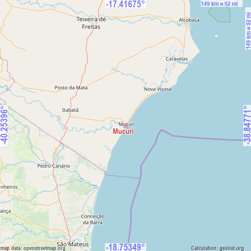
Mucuri GPS coordinates[2]
18° 5' 11.004" South, 39° 33' 2.988" West
| Map corner | latitude | longitude |
|---|---|---|
| Upper-left | -17.41675°, | -40.25396° |
| Center: | -18.08639°, | -39.55083° |
| Lower-right: | -18.75349°, | -38.84771° |
| Map W x H: | 148.6×148.6 km | = 92.3×92.3mi |
| max Lat: | 2.81972° ⇑51.2% North |
| Mucuri: | -18.08639° |
| min Lat: | ⇓48.8% South -33.69111° |
| min Long | Mucuri | max Long |
| -72.89583° | -39.55083° | -32.41083° |
| W 77.1%⇐ | ⇒22.9% E |
Elevation
Elevation of Mucuri is 7 m = 23 ft, and this is 373.9 m = 1227 ft below average elevation for this country.
| Max E: |
1603 m = 5259 ft | 97.2% |
| Avg. | 380.9 m = 1250 ft | |
| Mucuri | 7 m = 23 ft | |
Min E: |
0 m = 0 ft | 2.8% |
See also: Brazil elevation on elevation.city.
Geographical zone
Mucuri is located in South Torrid zone (between Equator and Tropic of Capricorn). Distance of this Southern Tropic circle is 594.9 km =369.7 mi to South.| Distance of | km | miles | from Mucuri |
|---|---|---|---|
| Equator | 2011 | 1249.6 | to North |
| Tropic Capricorn | 594.9 | 369.7 | to South |
| Antarctic Circle | 5390.2 | 3349.3 | to South |
| South Pole | 7996 | 4968.5 | to South |


Nearby cities:
15 places around Mucuri: (largest is in red/bold)
• Boa Esperança
93.4 km =58 mi,  237°
237°
• Carlos Chagas
135.5 km =84.2 mi,  288°
288°
• Conceição da Barra
59.5 km =37 mi,  198°
198°
• Itamaraju
116.5 km =72.4 mi,  1°
1°
• Itanhém
131.5 km =81.7 mi,  321°
321°
• Medeiros Neto
106.3 km =66.1 mi, 318°
• Montanha
86 km =53.4 mi,  266°
266°
• Mucurici
102 km =63.4 mi, 269°
• Nanuque
89.3 km =55.5 mi, 287°
• Nova Venécia
113.4 km =70.5 mi,  232°
232°
• Nova Viçosa
28.7 km =17.8 mi,  41°
41°
• Posto da Mata
39.1 km =24.3 mi,  304°
304°
• Prado
89.9 km =55.9 mi,  22°
22°
• São Mateus
77.6 km =48.2 mi, 204°
• Teixeira de Freitas
64.6 km =40.1 mi,  341°
341°
Sources, notices
• [Note1] Compared only with cities in Brazil existing in our database
• [Src1] Map data: © OpenStreetMap contributors (CC-BY-SA)
• [Src2] Other city data from geonames.org with taken over terms of usage.
• [Src3] Geographical zone / Annual Mean Temperature by Robert A. Rohde @ Wikipedia
