Medeiros Neto geodata
Medeiros Neto (Bahia) is a populated place; located in Brazil in America/Bahia (GMT-3) time zone. With population of 15,254 people, there are 1199 cities with bigger population in this country. Compared to other cities in Brazil, 50% of cities are located further ↓South; 74.3% of cities are located further ←West and 67.3% of cities have higher elevation than Medeiros Neto. Note1


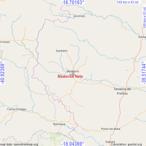
Medeiros Neto GPS coordinates[2]
17° 22' 26.004" South, 40° 13' 14.016" West
| Map corner | latitude | longitude |
|---|---|---|
| Upper-left | -16.70163°, | -40.92369° |
| Center: | -17.37389°, | -40.22056° |
| Lower-right: | -18.04369°, | -39.51744° |
| Map W x H: | 149.2×149.2 km | = 92.7×92.7mi |
| max Lat: | 2.81972° ⇑50% North |
| Medeiros Neto: | -17.37389° |
| min Lat: | ⇓50% South -33.69111° |
| min Long | Medeiros Neto | max Long |
| -72.89583° | -40.22056° | -32.41083° |
| W 74.3%⇐ | ⇒25.7% E |
Elevation
Elevation of Medeiros Neto is 150 m = 492 ft, and this is 230.9 m = 758 ft below average elevation for this country.
| Max E: |
1603 m = 5259 ft | 67.3% |
| Avg. | 380.9 m = 1250 ft | |
| Medeiros Neto | 150 m = 492 ft | |
Min E: |
0 m = 0 ft | 32.7% |
See also: Brazil elevation on elevation.city.
Geographical zone
Medeiros Neto is located in South Torrid zone (between Equator and Tropic of Capricorn). Distance of this Southern Tropic circle is 674.1 km =418.9 mi to South.| Distance of | km | miles | from Medeiros Neto |
|---|---|---|---|
| Equator | 1931.8 | 1200.4 | to North |
| Tropic Capricorn | 674.1 | 418.9 | to South |
| Antarctic Circle | 5469.4 | 3398.5 | to South |
| South Pole | 8075.3 | 5017.8 | to South |


Nearby cities:
15 places around Medeiros Neto: (largest is in red/bold)
• Carlos Chagas
68.5 km =42.6 mi,  237°
237°
• Ecoporanga
128.5 km =79.8 mi,  210°
210°
• Guaratinga
99.3 km =61.7 mi,  28°
28°
• Itamaraju
82.1 km =51 mi,  63°
63°
• Itanhém
25.8 km =16 mi,  333°
333°
• Joaíma
117.6 km =73.1 mi,  312°
312°
• Montanha
85.1 km =52.9 mi,  190°
190°
• Mucuri
106.3 km =66.1 mi,  138°
138°
• Mucurici
85.9 km =53.4 mi,  201°
201°
• Nanuque
53.6 km =33.3 mi, 195°
• Nova Viçosa
106.8 km =66.4 mi,  122°
122°
• Posto da Mata
69 km =42.9 mi,  145°
145°
• Prado
106.2 km =66 mi,  88°
88°
• Teixeira de Freitas
53.8 km =33.4 mi,  109°
109°
• Águas Formosas
82.6 km =51.3 mi,  293°
293°
Sources, notices
• [Note1] Compared only with cities in Brazil existing in our database
• [Src1] Map data: © OpenStreetMap contributors (CC-BY-SA)
• [Src2] Other city data from geonames.org with taken over terms of usage.
• [Src3] Geographical zone / Annual Mean Temperature by Robert A. Rohde @ Wikipedia
