Prado geodata
Prado (Bahia) is a populated place; located in Brazil in America/Bahia (GMT-3) time zone. With population of 15,464 people, there are 1192 cities with bigger population in this country. Compared to other cities in Brazil, 50.2% of cities are located further ↓South; 79.1% of cities are located further ←West and 93.7% of cities have higher elevation than Prado. Note1


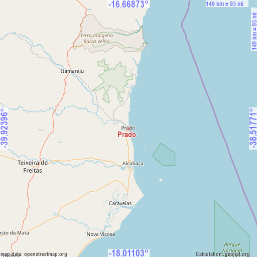
Prado GPS coordinates[2]
17° 20' 27.996" South, 39° 13' 14.988" West
| Map corner | latitude | longitude |
|---|---|---|
| Upper-left | -16.66873°, | -39.92396° |
| Center: | -17.34111°, | -39.22083° |
| Lower-right: | -18.01103°, | -38.51771° |
| Map W x H: | 149.2×149.3 km | = 92.7×92.8mi |
| max Lat: | 2.81972° ⇑49.8% North |
| Prado: | -17.34111° |
| min Lat: | ⇓50.2% South -33.69111° |
| min Long | Prado | max Long |
| -72.89583° | -39.22083° | -32.41083° |
| W 79.1%⇐ | ⇒20.9% E |
Elevation
Elevation of Prado is 11 m = 36 ft, and this is 369.9 m = 1214 ft below average elevation for this country.
| Max E: |
1603 m = 5259 ft | 93.7% |
| Avg. | 380.9 m = 1250 ft | |
| Prado | 11 m = 36 ft | |
Min E: |
0 m = 0 ft | 6.3% |
See also: Brazil elevation on elevation.city.
Geographical zone
Prado is located in South Torrid zone (between Equator and Tropic of Capricorn). Distance of this Southern Tropic circle is 677.8 km =421.2 mi to South.| Distance of | km | miles | from Prado |
|---|---|---|---|
| Equator | 1928.2 | 1198.1 | to North |
| Tropic Capricorn | 677.8 | 421.2 | to South |
| Antarctic Circle | 5473 | 3400.8 | to South |
| South Pole | 8078.9 | 5020 | to South |


Nearby cities:
15 places around Prado: (largest is in red/bold)
• Conceição da Barra
149.4 km =92.8 mi,  201°
201°
• Eunápolis
113.8 km =70.7 mi,  340°
340°
• Guaratinga
103 km =64 mi,  324°
324°
• Itamaraju
47 km =29.2 mi, 315°
• Itanhém
119.4 km =74.2 mi,  279°
279°
• Medeiros Neto
106.2 km =66 mi,  268°
268°
• Montanha
149.2 km =92.7 mi,  234°
234°
• Mucuri
89.9 km =55.9 mi, 202°
• Mucurici
160.6 km =99.8 mi,  238°
238°
• Nanuque
132.2 km =82.1 mi,  245°
245°
• Nova Viçosa
63.3 km =39.3 mi,  194°
194°
• Porto Seguro
100.5 km =62.4 mi,  9°
9°
• Posto da Mata
90.7 km =56.4 mi, 227°
• Santa Cruz Cabrália
120 km =74.6 mi, 10°
• Teixeira de Freitas
59.3 km =36.8 mi, 248°
Sources, notices
• [Note1] Compared only with cities in Brazil existing in our database
• [Src1] Map data: © OpenStreetMap contributors (CC-BY-SA)
• [Src2] Other city data from geonames.org with taken over terms of usage.
• [Src3] Geographical zone / Annual Mean Temperature by Robert A. Rohde @ Wikipedia
