Itamaraju geodata
Itamaraju (Bahia) is a populated place; located in Brazil in America/Bahia (GMT-3) time zone. With population of 47,628 people, there are 455 cities with bigger population in this country. Compared to other cities in Brazil, 50.9% of cities are located further ↓South; 77.2% of cities are located further ←West and 73.8% of cities have higher elevation than Itamaraju. Note1


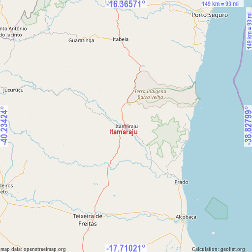
Itamaraju GPS coordinates[2]
17° 2' 21.012" South, 39° 31' 51.996" West
| Map corner | latitude | longitude |
|---|---|---|
| Upper-left | -16.36571°, | -40.23424° |
| Center: | -17.03917°, | -39.53111° |
| Lower-right: | -17.71021°, | -38.82799° |
| Map W x H: | 149.5×149.5 km | = 92.9×92.9mi |
| max Lat: | 2.81972° ⇑49.1% North |
| Itamaraju: | -17.03917° |
| min Lat: | ⇓50.9% South -33.69111° |
| min Long | Itamaraju | max Long |
| -72.89583° | -39.53111° | -32.41083° |
| W 77.2%⇐ | ⇒22.8% E |
Elevation
Elevation of Itamaraju is 89 m = 292 ft, and this is 291.9 m = 958 ft below average elevation for this country.
| Max E: |
1603 m = 5259 ft | 73.8% |
| Avg. | 380.9 m = 1250 ft | |
| Itamaraju | 89 m = 292 ft | |
Min E: |
0 m = 0 ft | 26.2% |
See also: Itamaraju elevation on elevation.city.
Geographical zone
Itamaraju is located in South Torrid zone (between Equator and Tropic of Capricorn). Distance of this Southern Tropic circle is 711.3 km =442 mi to South.| Distance of | km | miles | from Itamaraju |
|---|---|---|---|
| Equator | 1894.6 | 1177.2 | to North |
| Tropic Capricorn | 711.3 | 442 | to South |
| Antarctic Circle | 5506.6 | 3421.6 | to South |
| South Pole | 8112.5 | 5040.9 | to South |


Nearby cities:
15 places around Itamaraju: (largest is in red/bold)
• Belmonte
148.2 km =92.1 mi,  27°
27°
• Eunápolis
73.8 km =45.9 mi,  355°
355°
• Guaratinga
57.1 km =35.5 mi,  332°
332°
• Itanhém
86.1 km =53.5 mi,  260°
260°
• Medeiros Neto
82.1 km =51 mi,  243°
243°
• Montanha
149.7 km =93 mi,  216°
216°
• Mucuri
116.5 km =72.4 mi,  181°
181°
• Nanuque
124.6 km =77.4 mi, 224°
• Nova Viçosa
96.3 km =59.8 mi,  169°
169°
• Porto Seguro
82.2 km =51.1 mi,  37°
37°
• Posto da Mata
100.5 km =62.4 mi,  200°
200°
• Prado
47 km =29.2 mi,  135°
135°
• Santa Cruz Cabrália
100.4 km =62.4 mi, 32°
• Teixeira de Freitas
59.5 km =37 mi, 202°
• Águas Formosas
149.4 km =92.8 mi,  268°
268°
Sources, notices
• [Note1] Compared only with cities in Brazil existing in our database
• [Src1] Map data: © OpenStreetMap contributors (CC-BY-SA)
• [Src2] Other city data from geonames.org with taken over terms of usage.
• [Src3] Geographical zone / Annual Mean Temperature by Robert A. Rohde @ Wikipedia
