Mozarlândia geodata
Mozarlândia (Goiás) is a populated place; located in Brazil in America/Sao_Paulo (GMT-3) time zone. With population of 11,251 people, there are 1541 cities with bigger population in this country. Compared to other cities in Brazil, 56.8% of cities are located further ↓South; 80.6% of cities are located further →East and 53% of cities have higher elevation than Mozarlândia. Note1


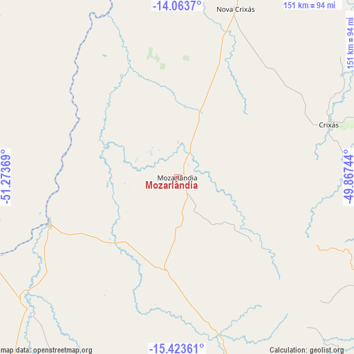
Mozarlândia GPS coordinates[2]
14° 44' 40.992" South, 50° 34' 14.016" West
| Map corner | latitude | longitude |
|---|---|---|
| Upper-left | -14.0637°, | -51.27369° |
| Center: | -14.74472°, | -50.57056° |
| Lower-right: | -15.42361°, | -49.86744° |
| Map W x H: | 151.2×151.2 km | = 94×94mi |
| max Lat: | 2.81972° ⇑43.2% North |
| Mozarlândia: | -14.74472° |
| min Lat: | ⇓56.8% South -33.69111° |
| min Long | Mozarlândia | max Long |
| -72.89583° | -50.57056° | -32.41083° |
| W 19.4%⇐ | ⇒80.6% E |
Elevation
Elevation of Mozarlândia is 300 m = 984 ft, and this is 80.9 m = 265 ft below average elevation for this country.
| Max E: |
1603 m = 5259 ft | 53% |
| Avg. | 380.9 m = 1250 ft | |
| Mozarlândia | 300 m = 984 ft | |
Min E: |
0 m = 0 ft | 47% |
See also: Brazil elevation on elevation.city.
Geographical zone
Mozarlândia is located in South Torrid zone (between Equator and Tropic of Capricorn). Distance of this Southern Tropic circle is 966.5 km =600.6 mi to South.| Distance of | km | miles | from Mozarlândia |
|---|---|---|---|
| Equator | 1639.5 | 1018.7 | to North |
| Tropic Capricorn | 966.5 | 600.6 | to South |
| Antarctic Circle | 5761.7 | 3580.2 | to South |
| South Pole | 8367.6 | 5199.4 | to South |


Nearby cities:
15 places around Mozarlândia: (largest is in red/bold)
• Carmo do Rio Verde
114.8 km =71.3 mi,  126°
126°
• Ceres
121.8 km =75.7 mi,  120°
120°
• Crixás
68.3 km =42.4 mi,  71°
71°
• Goianésia
168.5 km =104.7 mi,  112°
112°
• Goiás
140.1 km =87.1 mi,  160°
160°
• Itaberaí
163.6 km =101.7 mi,  150°
150°
• Itapaci
112.1 km =69.7 mi,  101°
101°
• Itapirapuã
120 km =74.6 mi,  182°
182°
• Itapuranga
112.8 km =70.1 mi,  143°
143°
• Jaraguá
173.9 km =108.1 mi, 130°
• Rialma
123.4 km =76.7 mi, 120°
• Rubiataba
94.7 km =58.8 mi, 119°
• São Miguel do Araguaia
169.2 km =105.1 mi,  15°
15°
• Uruana
127.3 km =79.1 mi, 131°
• Uruaçu
155.7 km =96.7 mi,  80°
80°
Sources, notices
• [Note1] Compared only with cities in Brazil existing in our database
• [Src1] Map data: © OpenStreetMap contributors (CC-BY-SA)
• [Src2] Other city data from geonames.org with taken over terms of usage.
• [Src3] Geographical zone / Annual Mean Temperature by Robert A. Rohde @ Wikipedia
