Encantado geodata
Encantado (Rio Grande do Sul) is a populated place; located in Brazil in America/Sao_Paulo (GMT-3) time zone. With population of 16,637 people, there are 1115 cities with bigger population in this country. Compared to other cities in Brazil, 96.4% of cities are located further ↑North; 87.2% of cities are located further →East and 75.7% of cities have higher elevation than Encantado. Note1


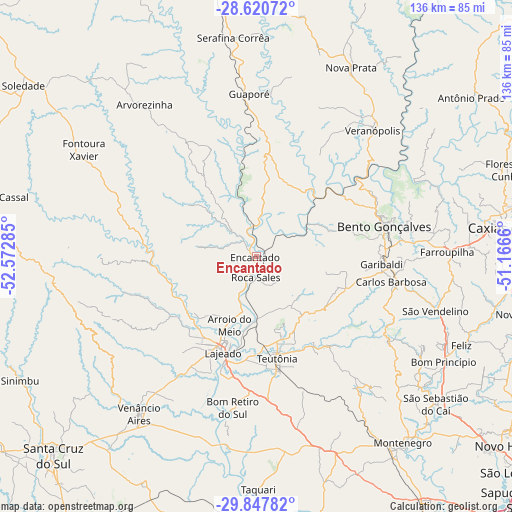
Encantado GPS coordinates[2]
29° 14' 9.996" South, 51° 52' 10.992" West
| Map corner | latitude | longitude |
|---|---|---|
| Upper-left | -28.62072°, | -52.57285° |
| Center: | -29.23611°, | -51.86972° |
| Lower-right: | -29.84782°, | -51.1666° |
| Map W x H: | 136.4×136.4 km | = 84.8×84.8mi |
| max Lat: | 2.81972° ⇑96.4% North |
| Encantado: | -29.23611° |
| min Lat: | ⇓3.6% South -33.69111° |
| min Long | Encantado | max Long |
| -72.89583° | -51.86972° | -32.41083° |
| W 12.8%⇐ | ⇒87.2% E |
Elevation
Elevation of Encantado is 73 m = 240 ft, and this is 307.9 m = 1010 ft below average elevation for this country.
| Max E: |
1603 m = 5259 ft | 75.7% |
| Avg. | 380.9 m = 1250 ft | |
| Encantado | 73 m = 240 ft | |
Min E: |
0 m = 0 ft | 24.3% |
See also: Brazil elevation on elevation.city.
Geographical zone
Encantado is located in South temperate zone (between Tropic of Capricorn and the Antarctic Circle). Distance of this Southern Tropic circle is 644.8 km =400.7 mi to North.| Distance of | km | miles | from Encantado |
|---|---|---|---|
| Equator | 3250.8 | 2020 | to North |
| Tropic Capricorn | 644.8 | 400.7 | to North |
| Antarctic Circle | 4150.4 | 2578.9 | to South |
| South Pole | 6756.3 | 4198.2 | to South |


Nearby cities:
15 places around Encantado: (largest is in red/bold)
• Arroio do Meio
19.7 km =12.2 mi,  201°
201°
• Bento Gonçalves
34.8 km =21.6 mi,  78°
78°
• Carlos Barbosa
36.2 km =22.5 mi,  100°
100°
• Caxias do Sul
67.4 km =41.9 mi, 83°
• Farroupilha
50.7 km =31.5 mi,  88°
88°
• Garibaldi
32.7 km =20.3 mi, 93°
• Guaporé
43.5 km =27 mi,  357°
357°
• Lajeado
27.2 km =16.9 mi, 199°
• Montenegro
64 km =39.8 mi,  141°
141°
• Nova Prata
56.3 km =35 mi,  26°
26°
• São Sebastião do Caí
61.7 km =38.3 mi,  129°
129°
• Taquari
62.7 km =39 mi,  179°
179°
• Teutônia
24.4 km =15.2 mi,  165°
165°
• Venâncio Aires
51.7 km =32.1 mi,  217°
217°
• Veranópolis
45.6 km =28.3 mi,  43°
43°
Sources, notices
• [Note1] Compared only with cities in Brazil existing in our database
• [Src1] Map data: © OpenStreetMap contributors (CC-BY-SA)
• [Src2] Other city data from geonames.org with taken over terms of usage.
• [Src3] Geographical zone / Annual Mean Temperature by Robert A. Rohde @ Wikipedia
