Farroupilha geodata
Farroupilha (Rio Grande do Sul) is a populated place; located in Brazil in America/Sao_Paulo (GMT-3) time zone. With population of 57,650 people, there are 379 cities with bigger population in this country. Compared to other cities in Brazil, 96.3% of cities are located further ↑North; 84.7% of cities are located further →East and 86.9% of cities have lower elevation than Farroupilha. Note1


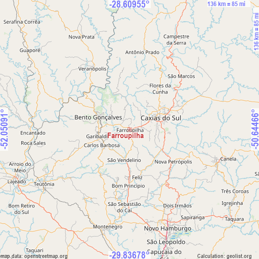
Farroupilha GPS coordinates[2]
29° 13' 30" South, 51° 20' 52.008" West
| Map corner | latitude | longitude |
|---|---|---|
| Upper-left | -28.60955°, | -52.05091° |
| Center: | -29.225°, | -51.34778° |
| Lower-right: | -29.83678°, | -50.64466° |
| Map W x H: | 136.5×136.5 km | = 84.8×84.8mi |
| max Lat: | 2.81972° ⇑96.3% North |
| Farroupilha: | -29.225° |
| min Lat: | ⇓3.7% South -33.69111° |
| min Long | Farroupilha | max Long |
| -72.89583° | -51.34778° | -32.41083° |
| W 15.3%⇐ | ⇒84.7% E |
Elevation
Elevation of Farroupilha is 773 m = 2536 ft, and this is 392.1 m = 1286 ft above average elevation for this country.
| Max E: |
1603 m = 5259 ft | 13.1% |
| Farroupilha | 773 m 2536 ft | |
| Avg. | 380.9 m = 1250 ft | |
Min E: |
0 m = 0 ft | 86.9% |
See also: Farroupilha elevation on elevation.city.
Geographical zone
Farroupilha is located in South temperate zone (between Tropic of Capricorn and the Antarctic Circle). Distance of this Southern Tropic circle is 643.6 km =399.9 mi to North.| Distance of | km | miles | from Farroupilha |
|---|---|---|---|
| Equator | 3249.5 | 2019.1 | to North |
| Tropic Capricorn | 643.6 | 399.9 | to North |
| Antarctic Circle | 4151.7 | 2579.7 | to South |
| South Pole | 6757.5 | 4198.9 | to South |


Nearby cities:
15 places around Farroupilha: (largest is in red/bold)
• Bento Gonçalves
17.7 km =11 mi,  289°
289°
• Canela
53.8 km =33.4 mi,  105°
105°
• Carlos Barbosa
17.1 km =10.6 mi,  241°
241°
• Caxias do Sul
17.5 km =10.9 mi,  68°
68°
• Encantado
50.7 km =31.5 mi,  268°
268°
• Estância Velha
50 km =31.1 mi,  160°
160°
• Flores da Cunha
27.1 km =16.8 mi,  36°
36°
• Garibaldi
18.4 km =11.4 mi,  259°
259°
• Ivoti
44.6 km =27.7 mi, 155°
• Montenegro
52.7 km =32.7 mi,  192°
192°
• Nova Petrópolis
28.2 km =17.5 mi,  126°
126°
• São Marcos
39.2 km =24.4 mi, 43°
• São Sebastião do Caí
40.3 km =25 mi,  183°
183°
• Teutônia
50.9 km =31.6 mi, 240°
• Veranópolis
37.6 km =23.4 mi,  328°
328°
Sources, notices
• [Note1] Compared only with cities in Brazil existing in our database
• [Src1] Map data: © OpenStreetMap contributors (CC-BY-SA)
• [Src2] Other city data from geonames.org with taken over terms of usage.
• [Src3] Geographical zone / Annual Mean Temperature by Robert A. Rohde @ Wikipedia
