Campos Novos geodata
Campos Novos (Santa Catarina) is a populated place; located in Brazil in America/Sao_Paulo (GMT-3) time zone. With population of 22,563 people, there are 850 cities with bigger population in this country. Compared to other cities in Brazil, 92% of cities are located further ↑North; 84.1% of cities are located further →East and 96.9% of cities have lower elevation than Campos Novos. Note1


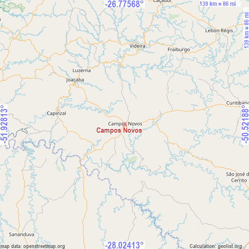
Campos Novos GPS coordinates[2]
27° 24' 6.012" South, 51° 13' 30" West
| Map corner | latitude | longitude |
|---|---|---|
| Upper-left | -26.77568°, | -51.92813° |
| Center: | -27.40167°, | -51.225° |
| Lower-right: | -28.02413°, | -50.52188° |
| Map W x H: | 138.8×138.8 km | = 86.2×86.2mi |
| max Lat: | 2.81972° ⇑92% North |
| Campos Novos: | -27.40167° |
| min Lat: | ⇓8% South -33.69111° |
| min Long | Campos Novos | max Long |
| -72.89583° | -51.225° | -32.41083° |
| W 15.9%⇐ | ⇒84.1% E |
Elevation
Elevation of Campos Novos is 937 m = 3074 ft, and this is 556.1 m = 1824 ft above average elevation for this country.
| Max E: |
1603 m = 5259 ft | 3.1% |
| Campos Novos | 937 m 3074 ft | |
| Avg. | 380.9 m = 1250 ft | |
Min E: |
0 m = 0 ft | 96.9% |
See also: Brazil elevation on elevation.city.
Geographical zone
Campos Novos is located in South temperate zone (between Tropic of Capricorn and the Antarctic Circle). Distance of this Southern Tropic circle is 440.9 km =274 mi to North.| Distance of | km | miles | from Campos Novos |
|---|---|---|---|
| Equator | 3046.8 | 1893.2 | to North |
| Tropic Capricorn | 440.9 | 274 | to North |
| Antarctic Circle | 4354.4 | 2705.7 | to South |
| South Pole | 6960.3 | 4324.9 | to South |


Nearby cities:
15 places around Campos Novos: (largest is in red/bold)
• Capinzal
38.7 km =24 mi,  279°
279°
• Caçador
72.7 km =45.2 mi,  16°
16°
• Celso Ramos
28.1 km =17.5 mi,  202°
202°
• Concórdia
81.5 km =50.6 mi, 283°
• Correia Pinto
87.6 km =54.4 mi,  103°
103°
• Curitibanos
64.6 km =40.1 mi,  78°
78°
• Erechim
106.8 km =66.4 mi,  255°
255°
• Estrela
78.6 km =48.8 mi,  158°
158°
• Joaçaba
37.2 km =23.1 mi,  311°
311°
• Lages
99.8 km =62 mi,  117°
117°
• Lagoa Vermelha
94.5 km =58.7 mi, 198°
• Sananduva
83.6 km =51.9 mi,  223°
223°
• Santa Cecília
92.9 km =57.7 mi,  58°
58°
• Tapejara
107.3 km =66.7 mi,  226°
226°
• Videira
44.3 km =27.5 mi,  9°
9°
Sources, notices
• [Note1] Compared only with cities in Brazil existing in our database
• [Src1] Map data: © OpenStreetMap contributors (CC-BY-SA)
• [Src2] Other city data from geonames.org with taken over terms of usage.
• [Src3] Geographical zone / Annual Mean Temperature by Robert A. Rohde @ Wikipedia
