Erechim geodata
Erechim (Rio Grande do Sul) is a populated place; located in Brazil in America/Sao_Paulo (GMT-3) time zone. With population of 96,087 people, there are 244 cities with bigger population in this country. Compared to other cities in Brazil, 92.9% of cities are located further ↑North; 88.6% of cities are located further →East and 88.4% of cities have lower elevation than Erechim. Note1


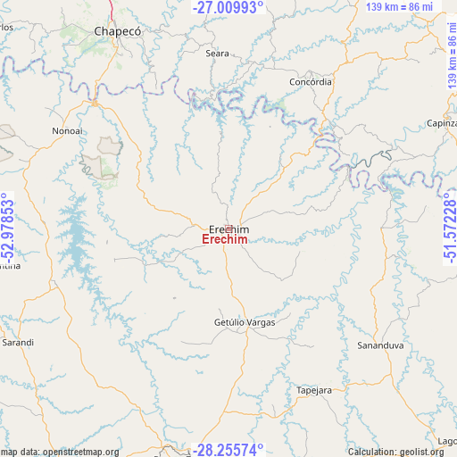
Erechim GPS coordinates[2]
27° 38' 4.596" South, 52° 16' 31.44" West
| Map corner | latitude | longitude |
|---|---|---|
| Upper-left | -27.00993°, | -52.97853° |
| Center: | -27.63461°, | -52.2754° |
| Lower-right: | -28.25574°, | -51.57228° |
| Map W x H: | 138.5×138.5 km | = 86.1×86.1mi |
| max Lat: | 2.81972° ⇑92.9% North |
| Erechim: | -27.63461° |
| min Lat: | ⇓7.1% South -33.69111° |
| min Long | Erechim | max Long |
| -72.89583° | -52.2754° | -32.41083° |
| W 11.4%⇐ | ⇒88.6% E |
Elevation
Elevation of Erechim is 790 m = 2592 ft, and this is 409.1 m = 1342 ft above average elevation for this country.
| Max E: |
1603 m = 5259 ft | 11.6% |
| Erechim | 790 m 2592 ft | |
| Avg. | 380.9 m = 1250 ft | |
Min E: |
0 m = 0 ft | 88.4% |
See also: Erechim elevation on elevation.city.
Geographical zone
Erechim is located in South temperate zone (between Tropic of Capricorn and the Antarctic Circle). Distance of this Southern Tropic circle is 466.8 km =290.1 mi to North.| Distance of | km | miles | from Erechim |
|---|---|---|---|
| Equator | 3072.7 | 1909.3 | to North |
| Tropic Capricorn | 466.8 | 290.1 | to North |
| Antarctic Circle | 4328.5 | 2689.6 | to South |
| South Pole | 6934.4 | 4308.8 | to South |


Nearby cities:
15 places around Erechim: (largest is in red/bold)
• Capinzal
73 km =45.4 mi,  63°
63°
• Carazinho
87.9 km =54.6 mi,  214°
214°
• Celso Ramos
92.5 km =57.5 mi,  89°
89°
• Chapecó
68.8 km =42.8 mi,  330°
330°
• Concórdia
50.8 km =31.6 mi,  28°
28°
• Joaçaba
91.5 km =56.9 mi, 56°
• Lagoa Vermelha
97.4 km =60.5 mi,  130°
130°
• Marau
90.9 km =56.5 mi,  175°
175°
• Não Me Toque
106.2 km =66 mi, 210°
• Palmeira das Missões
106.3 km =66.1 mi,  253°
253°
• Passo Fundo
71 km =44.1 mi,  190°
190°
• Sananduva
57.9 km =36 mi, 127°
• Sarandi
72.4 km =45 mi,  241°
241°
• Tapejara
54.6 km =33.9 mi,  151°
151°
• Xanxerê
85.2 km =52.9 mi,  351°
351°
Sources, notices
• [Note1] Compared only with cities in Brazil existing in our database
• [Src1] Map data: © OpenStreetMap contributors (CC-BY-SA)
• [Src2] Other city data from geonames.org with taken over terms of usage.
• [Src3] Geographical zone / Annual Mean Temperature by Robert A. Rohde @ Wikipedia
