Angatuba geodata
Angatuba (São Paulo) is a populated place; located in Brazil in America/Sao_Paulo (GMT-3) time zone. With population of 14,476 people, there are 1253 cities with bigger population in this country. Compared to other cities in Brazil, 82.6% of cities are located further ↑North; 66.6% of cities are located further →East and 75.1% of cities have lower elevation than Angatuba. Note1


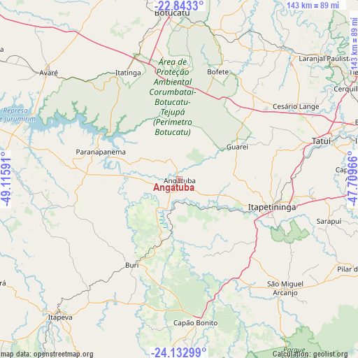
Angatuba GPS coordinates[2]
23° 29' 22.992" South, 48° 24' 46.008" West
| Map corner | latitude | longitude |
|---|---|---|
| Upper-left | -22.8433°, | -49.11591° |
| Center: | -23.48972°, | -48.41278° |
| Lower-right: | -24.13299°, | -47.70966° |
| Map W x H: | 143.4×143.4 km | = 89.1×89.1mi |
| max Lat: | 2.81972° ⇑82.6% North |
| Angatuba: | -23.48972° |
| min Lat: | ⇓17.4% South -33.69111° |
| min Long | Angatuba | max Long |
| -72.89583° | -48.41278° | -32.41083° |
| W 33.4%⇐ | ⇒66.6% E |
Elevation
Elevation of Angatuba is 627 m = 2057 ft, and this is 246.1 m = 807 ft above average elevation for this country.
| Max E: |
1603 m = 5259 ft | 24.9% |
| Angatuba | 627 m 2057 ft | |
| Avg. | 380.9 m = 1250 ft | |
Min E: |
0 m = 0 ft | 75.1% |
See also: Brazil elevation on elevation.city.
Geographical zone
Angatuba is located in South temperate zone (between Tropic of Capricorn and the Antarctic Circle). Distance of this Southern Tropic circle is 5.9 km =3.7 mi to North.| Distance of | km | miles | from Angatuba |
|---|---|---|---|
| Equator | 2611.8 | 1622.9 | to North |
| Tropic Capricorn | 5.9 | 3.7 | to North |
| Antarctic Circle | 4789.4 | 2976 | to South |
| South Pole | 7395.2 | 4595.2 | to South |


Nearby cities:
15 places around Angatuba: (largest is in red/bold)
• Avaré
68.1 km =42.3 mi,  309°
309°
• Botucatu
67.2 km =41.8 mi,  357°
357°
• Buri
38.8 km =24.1 mi,  208°
208°
• Capela do Alto
69.2 km =43 mi,  88°
88°
• Capâo Bonito
57.7 km =35.9 mi,  173°
173°
• Conchas
66.9 km =41.6 mi,  37°
37°
• Iperó
75.5 km =46.9 mi,  78°
78°
• Itapetininga
38.4 km =23.9 mi,  107°
107°
• Itapeva
72.2 km =44.9 mi,  220°
220°
• Itatinga
47.9 km =29.8 mi,  334°
334°
• Itaí
69.6 km =43.2 mi,  276°
276°
• Laranjal Paulista
76.5 km =47.5 mi,  50°
50°
• Paranapanema
33.8 km =21 mi,  289°
289°
• Porangaba
45.6 km =28.3 mi, 40°
• Tatuí
58.6 km =36.4 mi, 75°
Sources, notices
• [Note1] Compared only with cities in Brazil existing in our database
• [Src1] Map data: © OpenStreetMap contributors (CC-BY-SA)
• [Src2] Other city data from geonames.org with taken over terms of usage.
• [Src3] Geographical zone / Annual Mean Temperature by Robert A. Rohde @ Wikipedia
