Veranópolis geodata
Veranópolis (Rio Grande do Sul) is a populated place; located in Brazil in America/Sao_Paulo (GMT-3) time zone. With population of 19,861 people, there are 947 cities with bigger population in this country. Compared to other cities in Brazil, 95.8% of cities are located further ↑North; 85.7% of cities are located further →East and 78.1% of cities have lower elevation than Veranópolis. Note1


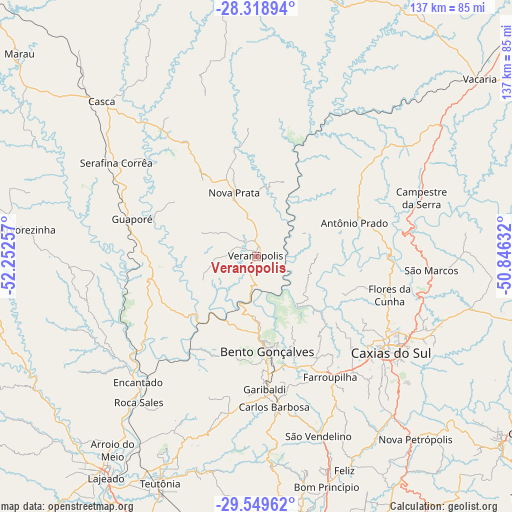
Veranópolis GPS coordinates[2]
28° 56' 9.996" South, 51° 32' 57.984" West
| Map corner | latitude | longitude |
|---|---|---|
| Upper-left | -28.31894°, | -52.25257° |
| Center: | -28.93611°, | -51.54944° |
| Lower-right: | -29.54962°, | -50.84632° |
| Map W x H: | 136.8×136.8 km | = 85×85mi |
| max Lat: | 2.81972° ⇑95.8% North |
| Veranópolis: | -28.93611° |
| min Lat: | ⇓4.2% South -33.69111° |
| min Long | Veranópolis | max Long |
| -72.89583° | -51.54944° | -32.41083° |
| W 14.3%⇐ | ⇒85.7% E |
Elevation
Elevation of Veranópolis is 669 m = 2195 ft, and this is 288.1 m = 945 ft above average elevation for this country.
| Max E: |
1603 m = 5259 ft | 21.9% |
| Veranópolis | 669 m 2195 ft | |
| Avg. | 380.9 m = 1250 ft | |
Min E: |
0 m = 0 ft | 78.1% |
See also: Brazil elevation on elevation.city.
Geographical zone
Veranópolis is located in South temperate zone (between Tropic of Capricorn and the Antarctic Circle). Distance of this Southern Tropic circle is 611.5 km =380 mi to North.| Distance of | km | miles | from Veranópolis |
|---|---|---|---|
| Equator | 3217.4 | 1999.2 | to North |
| Tropic Capricorn | 611.5 | 380 | to North |
| Antarctic Circle | 4183.8 | 2599.7 | to South |
| South Pole | 6789.7 | 4218.9 | to South |


Nearby cities:
15 places around Veranópolis: (largest is in red/bold)
• Arroio do Meio
64.4 km =40 mi,  216°
216°
• Bento Gonçalves
26.3 km =16.3 mi,  173°
173°
• Carlos Barbosa
40.4 km =25.1 mi, 173°
• Caxias do Sul
44.3 km =27.5 mi,  125°
125°
• Encantado
45.6 km =28.3 mi, 223°
• Farroupilha
37.6 km =23.4 mi,  148°
148°
• Flores da Cunha
37.2 km =23.1 mi,  106°
106°
• Garibaldi
35.6 km =22.1 mi,  177°
177°
• Guaporé
34.7 km =21.6 mi,  286°
286°
• Lajeado
71.3 km =44.3 mi,  214°
214°
• Nova Petrópolis
64.7 km =40.2 mi,  139°
139°
• Nova Prata
17.9 km =11.1 mi,  340°
340°
• São Marcos
47 km =29.2 mi,  94°
94°
• São Sebastião do Caí
74.3 km =46.2 mi, 166°
• Teutônia
62.1 km =38.6 mi,  203°
203°
Sources, notices
• [Note1] Compared only with cities in Brazil existing in our database
• [Src1] Map data: © OpenStreetMap contributors (CC-BY-SA)
• [Src2] Other city data from geonames.org with taken over terms of usage.
• [Src3] Geographical zone / Annual Mean Temperature by Robert A. Rohde @ Wikipedia
