Cristalina geodata
Cristalina (Goiás) is a seat of a second-order administrative division; located in Brazil in America/Sao_Paulo (GMT-3) time zone. With population of 36,531 people, there are 563 cities with bigger population in this country. Compared to other cities in Brazil, 51.4% of cities are located further ↓South; 62.6% of cities are located further →East and 99.8% of cities have lower elevation than Cristalina. Note1


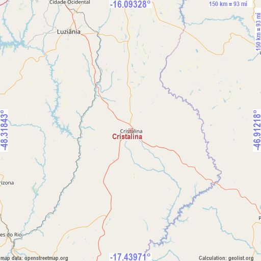
Cristalina GPS coordinates[2]
16° 46' 3.684" South, 47° 36' 55.08" West
| Map corner | latitude | longitude |
|---|---|---|
| Upper-left | -16.09328°, | -48.31843° |
| Center: | -16.76769°, | -47.6153° |
| Lower-right: | -17.43971°, | -46.91218° |
| Map W x H: | 149.7×149.7 km | = 93×93mi |
| max Lat: | 2.81972° ⇑48.6% North |
| Cristalina: | -16.76769° |
| min Lat: | ⇓51.4% South -33.69111° |
| min Long | Cristalina | max Long |
| -72.89583° | -47.6153° | -32.41083° |
| W 37.4%⇐ | ⇒62.6% E |
Elevation
Elevation of Cristalina is 1229 m = 4032 ft, and this is 848.1 m = 2782 ft above average elevation for this country.
| Max E: |
1603 m = 5259 ft | 0.2% |
| Cristalina | 1229 m 4032 ft | |
| Avg. | 380.9 m = 1250 ft | |
Min E: |
0 m = 0 ft | 99.8% |
See also: Brazil elevation on elevation.city.
Geographical zone
Cristalina is located in South Torrid zone (between Equator and Tropic of Capricorn). Distance of this Southern Tropic circle is 741.5 km =460.7 mi to South.| Distance of | km | miles | from Cristalina |
|---|---|---|---|
| Equator | 1864.4 | 1158.5 | to North |
| Tropic Capricorn | 741.5 | 460.7 | to South |
| Antarctic Circle | 5536.8 | 3440.4 | to South |
| South Pole | 8142.7 | 5059.6 | to South |


Nearby cities:
15 places around Cristalina: (largest is in red/bold)
• Abadiânia
132.2 km =82.1 mi,  298°
298°
• Anápolis
150.8 km =93.7 mi,  288°
288°
• Bela Vista de Goiás
144.2 km =89.6 mi,  260°
260°
• Brasília
114.9 km =71.4 mi,  343°
343°
• Formosa
140.1 km =87.1 mi,  12°
12°
• Ipameri
120.8 km =75.1 mi,  208°
208°
• Luziânia
67.5 km =41.9 mi,  328°
328°
• Orizona
78.1 km =48.5 mi,  247°
247°
• Paracatu
93.6 km =58.2 mi,  122°
122°
• Pires do Rio
92.1 km =57.2 mi,  230°
230°
• Planaltina
127.9 km =79.5 mi,  358°
358°
• Planaltina
146.2 km =90.8 mi,  0°
0°
• Silvânia
106.4 km =66.1 mi,  276°
276°
• Unaí
88.3 km =54.9 mi,  58°
58°
• Vianópolis
96 km =59.7 mi,  271°
271°
Sources, notices
• [Note1] Compared only with cities in Brazil existing in our database
• [Src1] Map data: © OpenStreetMap contributors (CC-BY-SA)
• [Src2] Other city data from geonames.org with taken over terms of usage.
• [Src3] Geographical zone / Annual Mean Temperature by Robert A. Rohde @ Wikipedia
