Ipameri geodata
Ipameri (Goiás) is a populated place; located in Brazil in America/Sao_Paulo (GMT-3) time zone. With population of 18,607 people, there are 1004 cities with bigger population in this country. Compared to other cities in Brazil, 50.4% of cities are located further ↑North; 65.4% of cities are located further →East and 86.9% of cities have lower elevation than Ipameri. Note1


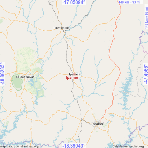
Ipameri GPS coordinates[2]
17° 43' 18.984" South, 48° 9' 34.992" West
| Map corner | latitude | longitude |
|---|---|---|
| Upper-left | -17.05094°, | -48.86285° |
| Center: | -17.72194°, | -48.15972° |
| Lower-right: | -18.39043°, | -47.4566° |
| Map W x H: | 148.9×148.9 km | = 92.5×92.5mi |
| max Lat: | 2.81972° ⇑50.4% North |
| Ipameri: | -17.72194° |
| min Lat: | ⇓49.6% South -33.69111° |
| min Long | Ipameri | max Long |
| -72.89583° | -48.15972° | -32.41083° |
| W 34.6%⇐ | ⇒65.4% E |
Elevation
Elevation of Ipameri is 773 m = 2536 ft, and this is 392.1 m = 1286 ft above average elevation for this country.
| Max E: |
1603 m = 5259 ft | 13.1% |
| Ipameri | 773 m 2536 ft | |
| Avg. | 380.9 m = 1250 ft | |
Min E: |
0 m = 0 ft | 86.9% |
See also: Brazil elevation on elevation.city.
Geographical zone
Ipameri is located in South Torrid zone (between Equator and Tropic of Capricorn). Distance of this Southern Tropic circle is 635.4 km =394.8 mi to South.| Distance of | km | miles | from Ipameri |
|---|---|---|---|
| Equator | 1970.5 | 1224.4 | to North |
| Tropic Capricorn | 635.4 | 394.8 | to South |
| Antarctic Circle | 5430.7 | 3374.5 | to South |
| South Pole | 8036.6 | 4993.7 | to South |


Nearby cities:
15 places around Ipameri: (largest is in red/bold)
• Araguari
102.9 km =63.9 mi,  181°
181°
• Bela Vista de Goiás
118.5 km =73.6 mi,  314°
314°
• Buriti Alegre
104.1 km =64.7 mi,  243°
243°
• Caldas Novas
49.6 km =30.8 mi,  267°
267°
• Catalão
54.3 km =33.7 mi,  155°
155°
• Coromandel
131.4 km =81.6 mi,  129°
129°
• Cristalina
120.8 km =75.1 mi,  28°
28°
• Goiatuba
130.5 km =81.1 mi,  255°
255°
• Morrinhos
99.5 km =61.8 mi, 269°
• Orizona
78.1 km =48.5 mi,  349°
349°
• Piracanjuba
102.1 km =63.4 mi,  297°
297°
• Pires do Rio
48.6 km =30.2 mi,  344°
344°
• Silvânia
127.4 km =79.2 mi, 338°
• Tupaciguara
112.6 km =70 mi,  210°
210°
• Vianópolis
115.4 km =71.7 mi, 340°
Sources, notices
• [Note1] Compared only with cities in Brazil existing in our database
• [Src1] Map data: © OpenStreetMap contributors (CC-BY-SA)
• [Src2] Other city data from geonames.org with taken over terms of usage.
• [Src3] Geographical zone / Annual Mean Temperature by Robert A. Rohde @ Wikipedia
