Costa Rica geodata
Costa Rica (Mato Grosso do Sul) is a populated place; located in Brazil in America/Campo_Grande (GMT-4) time zone. With population of 12,930 people, there are 1375 cities with bigger population in this country. Compared to other cities in Brazil, 82% of cities are located further ↑North; 93.6% of cities are located further →East and 53% of cities have lower elevation than Costa Rica. Note1


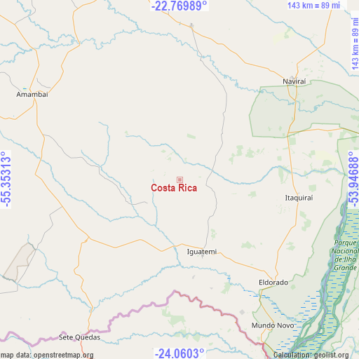
Costa Rica GPS coordinates[2]
23° 25' 0.012" South, 54° 39' 0" West
| Map corner | latitude | longitude |
|---|---|---|
| Upper-left | -22.76989°, | -55.35313° |
| Center: | -23.41667°, | -54.65° |
| Lower-right: | -24.0603°, | -53.94688° |
| Map W x H: | 143.5×143.5 km | = 89.2×89.2mi |
| max Lat: | 2.81972° ⇑82% North |
| Costa Rica: | -23.41667° |
| min Lat: | ⇓18% South -33.69111° |
| min Long | Costa Rica | max Long |
| -72.89583° | -54.65° | -32.41083° |
| W 6.4%⇐ | ⇒93.6% E |
Elevation
Elevation of Costa Rica is 394 m = 1293 ft, and this is 13.1 m = 43 ft above average elevation for this country.
| Max E: |
1603 m = 5259 ft | 47% |
| Costa Rica | 394 m 1293 ft | |
| Avg. | 380.9 m = 1250 ft | |
Min E: |
0 m = 0 ft | 53% |
See also: Brazil elevation on elevation.city.
Geographical zone
Costa Rica is located in South Torrid zone (between Equator and Tropic of Capricorn). Distance of this Southern Tropic circle is 2.2 km =1.4 mi to South.| Distance of | km | miles | from Costa Rica |
|---|---|---|---|
| Equator | 2603.7 | 1617.9 | to North |
| Tropic Capricorn | 2.2 | 1.4 | to South |
| Antarctic Circle | 4797.5 | 2981 | to South |
| South Pole | 7403.4 | 4600.3 | to South |


Nearby cities:
15 places around Costa Rica: (largest is in red/bold)
• Alto Piquiri
140.6 km =87.4 mi,  118°
118°
• Altãnia
91.7 km =57 mi, 123°
• Caarapó
88.8 km =55.2 mi,  348°
348°
• Dourados
133.9 km =83.2 mi, 353°
• Eldorado
55.6 km =34.5 mi,  137°
137°
• Iguatemi
30.7 km =19.1 mi,  162°
162°
• Iporã
116.3 km =72.3 mi, 124°
• Loanda
164.1 km =102 mi,  70°
70°
• Marechal Cândido Rondon
140.3 km =87.2 mi,  154°
154°
• Naviraí
61.1 km =38 mi,  50°
50°
• Palotina
126.8 km =78.8 mi, 139°
• Paranhos
95.6 km =59.4 mi,  236°
236°
• Ponta Porã
147.3 km =91.5 mi,  311°
311°
• Pôrto Barra do Ivinheima
112.3 km =69.8 mi,  63°
63°
• Umuarama
140.5 km =87.3 mi,  106°
106°
Sources, notices
• [Note1] Compared only with cities in Brazil existing in our database
• [Src1] Map data: © OpenStreetMap contributors (CC-BY-SA)
• [Src2] Other city data from geonames.org with taken over terms of usage.
• [Src3] Geographical zone / Annual Mean Temperature by Robert A. Rohde @ Wikipedia
