Santa Isabel do Rio Negro geodata
Santa Isabel do Rio Negro (Amazonas) is a populated place; located in Brazil in America/Manaus (GMT-4) time zone. With population of 4,142 people, there are 1958 cities with bigger population in this country. Compared to other cities in Brazil, 99.7% of cities are located further ↓South; 98.5% of cities are located further →East and 80.2% of cities have higher elevation than Santa Isabel do Rio Negro. Note1
Current local time in Santa Isabel do Rio Negro:
07:24 PM, TuesdayDifference from your time zone: hours


Santa Isabel do Rio Negro GPS coordinates[2]
0° 24' 50.004" South, 65° 1' 9.012" West
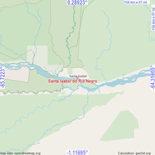
| Map corner | latitude | longitude |
|---|---|---|
| Upper-left | 0.28923°, | -65.7223° |
| Center: | -0.41389°, | -65.01917° |
| Lower-right: | -1.11695°, | -64.31605° |
| Map W x H: | 156.4×156.4 km | = 97.2×97.2mi |
| max Lat: | 2.81972° ⇑0.3% North |
| Santa Isabel do Rio Negro: | -0.41389° |
| min Lat: | ⇓99.7% South -33.69111° |
| min Long | Santa Isabel do | max Long |
| -72.89583° | -65.01917° | -32.41083° |
| W 1.5%⇐ | ⇒98.5% E |
Elevation
Elevation of Santa Isabel do Rio Negro is 45 m = 148 ft, and this is 335.9 m = 1102 ft below average elevation for this country.
| Max E: |
1603 m = 5259 ft | 80.2% |
| Avg. | 380.9 m = 1250 ft | |
| Santa Isabel do Rio Negro | 45 m = 148 ft | |
Min E: |
0 m = 0 ft | 19.8% |
See also: Brazil elevation on elevation.city.
Geographical zone
Santa Isabel do Rio Negro is located in South Torrid zone (between Equator and Tropic of Capricorn). Distance of Equator is 46 km =28.6 mi to North.| Distance of | km | miles | from Santa Isabel do Rio Negro |
|---|---|---|---|
| Equator | 46 | 28.6 | to North |
| Tropic Capricorn | 2559.9 | 1590.6 | to South |
| Antarctic Circle | 7355.2 | 4570.3 | to South |
| South Pole | 9961 | 6189.5 | to South |


Nearby cities:
9 places around Santa Isabel do Rio Negro: (largest is in red/bold)
• Alvarães
313 km =194.5 mi,  175°
175°
• Barcelos
240.8 km =149.6 mi,  104°
104°
• Fonte Boa
262.2 km =162.9 mi,  207°
207°
• Maraã
161.3 km =100.2 mi,  193°
193°
• Santo Antônio do Içá
441.2 km =274.1 mi,  227°
227°
• São Gabriel da Cachoeira
232.1 km =144.2 mi,  278°
278°
• Tefé
330.2 km =205.2 mi,  174°
174°
• Tonantins
412.8 km =256.5 mi, 228°
• Uarini
286.6 km =178.1 mi, 181°
Sources, notices
• [Note1] Compared only with cities in Brazil existing in our database
• [Src1] Map data: © OpenStreetMap contributors (CC-BY-SA)
• [Src2] Other city data from geonames.org with taken over terms of usage.
• [Src3] Geographical zone / Annual Mean Temperature by Robert A. Rohde @ Wikipedia
