Maraã geodata
Maraã (Amazonas) is a populated locality; located in Brazil in America/Manaus (GMT-4) time zone. With population of 4,387 people, there are 1949 cities with bigger population in this country. Compared to other cities in Brazil, 97.8% of cities are located further ↓South; 98.7% of cities are located further →East and 75.4% of cities have higher elevation than Maraã. Note1


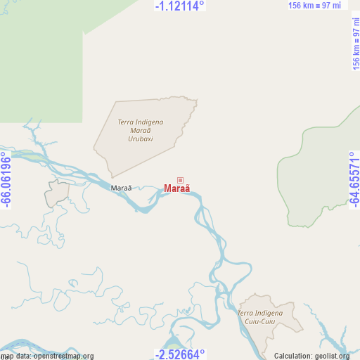
Maraã GPS coordinates[2]
1° 49' 26.508" South, 65° 21' 31.788" West
| Map corner | latitude | longitude |
|---|---|---|
| Upper-left | -1.12114°, | -66.06196° |
| Center: | -1.82403°, | -65.35883° |
| Lower-right: | -2.52664°, | -64.65571° |
| Map W x H: | 156.3×156.3 km | = 97.1×97.1mi |
| max Lat: | 2.81972° ⇑2.2% North |
| Maraã: | -1.82403° |
| min Lat: | ⇓97.8% South -33.69111° |
| min Long | Maraã | max Long |
| -72.89583° | -65.35883° | -32.41083° |
| W 1.3%⇐ | ⇒98.7% E |
Elevation
Elevation of Maraã is 74 m = 243 ft, and this is 306.9 m = 1007 ft below average elevation for this country.
| Max E: |
1603 m = 5259 ft | 75.4% |
| Avg. | 380.9 m = 1250 ft | |
| Maraã | 74 m = 243 ft | |
Min E: |
0 m = 0 ft | 24.6% |
See also: Brazil elevation on elevation.city.
Geographical zone
Maraã is located in South Torrid zone (between Equator and Tropic of Capricorn). Distance of Equator is 202.8 km =126 mi to North.| Distance of | km | miles | from Maraã |
|---|---|---|---|
| Equator | 202.8 | 126 | to North |
| Tropic Capricorn | 2403.1 | 1493.2 | to South |
| Antarctic Circle | 7198.4 | 4472.9 | to South |
| South Pole | 9804.2 | 6092 | to South |


Nearby cities:
13 places around Maraã: (largest is in red/bold)
• Alvarães
167.1 km =103.8 mi,  158°
158°
• Barcelos
286.4 km =178 mi,  70°
70°
• Carauari
380.5 km =236.4 mi,  206°
206°
• Coari
351.9 km =218.7 mi,  135°
135°
• Codajás
429.6 km =266.9 mi,  121°
121°
• Fonte Boa
111.9 km =69.5 mi,  226°
226°
• Santa Isabel do Rio Negro
161.3 km =100.2 mi,  13°
13°
• Santo Antônio do Içá
320 km =198.8 mi,  243°
243°
• São Gabriel da Cachoeira
269.8 km =167.6 mi,  314°
314°
• São Paulo de Olivença
426.8 km =265.2 mi,  246°
246°
• Tefé
185.8 km =115.5 mi, 157°
• Tonantins
295.4 km =183.6 mi, 246°
• Uarini
132.6 km =82.4 mi,  167°
167°
Sources, notices
• [Note1] Compared only with cities in Brazil existing in our database
• [Src1] Map data: © OpenStreetMap contributors (CC-BY-SA)
• [Src2] Other city data from geonames.org with taken over terms of usage.
• [Src3] Geographical zone / Annual Mean Temperature by Robert A. Rohde @ Wikipedia
