Fonte Boa geodata
Fonte Boa (Amazonas) is a seat of a second-order administrative division; located in Brazil in America/Manaus (GMT-4) time zone. With population of 16,060 people, there are 1154 cities with bigger population in this country. Compared to other cities in Brazil, 96.8% of cities are located further ↓South; 98.7% of cities are located further →East and 77.6% of cities have higher elevation than Fonte Boa. Note1


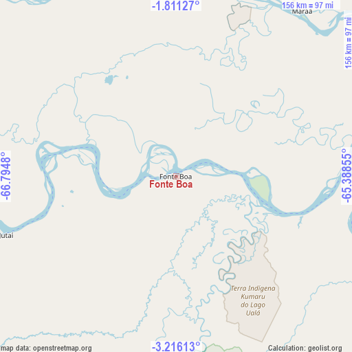
Fonte Boa GPS coordinates[2]
2° 30' 50.004" South, 66° 5' 30.012" West
| Map corner | latitude | longitude |
|---|---|---|
| Upper-left | -1.81127°, | -66.7948° |
| Center: | -2.51389°, | -66.09167° |
| Lower-right: | -3.21613°, | -65.38855° |
| Map W x H: | 156.2×156.2 km | = 97.1×97.1mi |
| max Lat: | 2.81972° ⇑3.2% North |
| Fonte Boa: | -2.51389° |
| min Lat: | ⇓96.8% South -33.69111° |
| min Long | Fonte Boa | max Long |
| -72.89583° | -66.09167° | -32.41083° |
| W 1.3%⇐ | ⇒98.7% E |
Elevation
Elevation of Fonte Boa is 60 m = 197 ft, and this is 320.9 m = 1053 ft below average elevation for this country.
| Max E: |
1603 m = 5259 ft | 77.6% |
| Avg. | 380.9 m = 1250 ft | |
| Fonte Boa | 60 m = 197 ft | |
Min E: |
0 m = 0 ft | 22.4% |
See also: Brazil elevation on elevation.city.
Geographical zone
Fonte Boa is located in South Torrid zone (between Equator and Tropic of Capricorn). Distance of Equator is 279.5 km =173.7 mi to North.| Distance of | km | miles | from Fonte Boa |
|---|---|---|---|
| Equator | 279.5 | 173.7 | to North |
| Tropic Capricorn | 2326.4 | 1445.6 | to South |
| Antarctic Circle | 7121.7 | 4425.2 | to South |
| South Pole | 9727.5 | 6044.4 | to South |


Nearby cities:
13 places around Fonte Boa: (largest is in red/bold)
• Alvarães
163.2 km =101.4 mi,  118°
118°
• Barcelos
391.2 km =243.1 mi,  64°
64°
• Carauari
278.1 km =172.8 mi,  198°
198°
• Coari
371.2 km =230.7 mi, 118°
• Jutaí
430.3 km =267.4 mi,  226°
226°
• Maraã
111.9 km =69.5 mi,  46°
46°
• Santa Isabel do Rio Negro
262.2 km =162.9 mi,  27°
27°
• Santo Antônio do Içá
215.4 km =133.8 mi,  252°
252°
• São Gabriel da Cachoeira
288.4 km =179.2 mi,  337°
337°
• São Paulo de Olivença
323.4 km =201 mi, 252°
• Tefé
179.5 km =111.5 mi, 121°
• Tonantins
194.1 km =120.6 mi,  258°
258°
• Uarini
121.4 km =75.4 mi, 115°
Sources, notices
• [Note1] Compared only with cities in Brazil existing in our database
• [Src1] Map data: © OpenStreetMap contributors (CC-BY-SA)
• [Src2] Other city data from geonames.org with taken over terms of usage.
• [Src3] Geographical zone / Annual Mean Temperature by Robert A. Rohde @ Wikipedia
