Ji Paraná geodata
Ji Paraná (Rondônia) is a populated place; located in Brazil in America/Porto_Velho (GMT-4) time zone. With population of 107,697 people, there are 210 cities with bigger population in this country. Compared to other cities in Brazil, 65.2% of cities are located further ↓South; 97.9% of cities are located further →East and 66.1% of cities have higher elevation than Ji Paraná. Note1


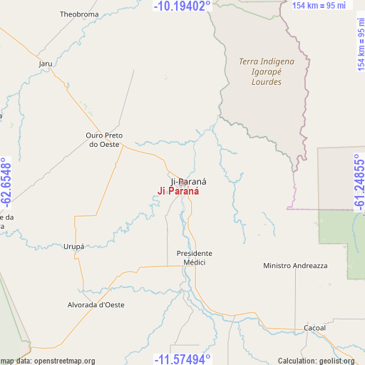
Ji Paraná GPS coordinates[2]
10° 53' 7.008" South, 61° 57' 6.012" West
| Map corner | latitude | longitude |
|---|---|---|
| Upper-left | -10.19402°, | -62.6548° |
| Center: | -10.88528°, | -61.95167° |
| Lower-right: | -11.57494°, | -61.24855° |
| Map W x H: | 153.5×153.5 km | = 95.4×95.4mi |
| max Lat: | 2.81972° ⇑34.8% North |
| Ji Paraná: | -10.88528° |
| min Lat: | ⇓65.2% South -33.69111° |
| min Long | Ji Paraná | max Long |
| -72.89583° | -61.95167° | -32.41083° |
| W 2.1%⇐ | ⇒97.9% E |
Elevation
Elevation of Ji Paraná is 157 m = 515 ft, and this is 223.9 m = 735 ft below average elevation for this country.
| Max E: |
1603 m = 5259 ft | 66.1% |
| Avg. | 380.9 m = 1250 ft | |
| Ji Paraná | 157 m = 515 ft | |
Min E: |
0 m = 0 ft | 33.9% |
See also: Ji Paraná elevation on elevation.city.
Geographical zone
Ji Paraná is located in South Torrid zone (between Equator and Tropic of Capricorn). Distance of Equator is 1210.3 km =752 mi to North.| Distance of | km | miles | from Ji Paraná |
|---|---|---|---|
| Equator | 1210.3 | 752 | to North |
| Tropic Capricorn | 1395.6 | 867.2 | to South |
| Antarctic Circle | 6190.8 | 3846.8 | to South |
| South Pole | 8796.7 | 5466 | to South |


Nearby cities:
12 places around Ji Paraná: (largest is in red/bold)
• Aripuanã
239.5 km =148.8 mi,  37°
37°
• Ariquemes
160.8 km =99.9 mi,  312°
312°
• Cacoal
82.5 km =51.3 mi,  138°
138°
• Guajará Mirim
369.7 km =229.7 mi,  271°
271°
• Humaitá
392.9 km =244.1 mi,  342°
342°
• Jaru
75 km =46.6 mi, 311°
• Ouro Preto do Oeste
32.6 km =20.3 mi,  297°
297°
• Pimenta Bueno
120.4 km =74.8 mi, 136°
• Porto Velho
318.6 km =198 mi,  317°
317°
• Presidente Médici
32.7 km =20.3 mi,  170°
170°
• Pôsto Fiscal Rolim de Moura
246.9 km =153.4 mi,  188°
188°
• Vilhena
284.9 km =177 mi, 136°
Sources, notices
• [Note1] Compared only with cities in Brazil existing in our database
• [Src1] Map data: © OpenStreetMap contributors (CC-BY-SA)
• [Src2] Other city data from geonames.org with taken over terms of usage.
• [Src3] Geographical zone / Annual Mean Temperature by Robert A. Rohde @ Wikipedia
