Aripuanã geodata
Aripuanã (Mato Grosso) is a populated place; located in Brazil in America/Cuiaba (GMT-4) time zone. With population of 26,983 people, there are 734 cities with bigger population in this country. Compared to other cities in Brazil, 70.7% of cities are located further ↓South; 97.5% of cities are located further →East and 67.8% of cities have higher elevation than Aripuanã. Note1


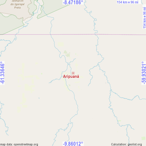
Aripuanã GPS coordinates[2]
9° 10' 0.012" South, 60° 37' 59.988" West
| Map corner | latitude | longitude |
|---|---|---|
| Upper-left | -8.47186°, | -61.33646° |
| Center: | -9.16667°, | -60.63333° |
| Lower-right: | -9.86012°, | -59.93021° |
| Map W x H: | 154.4×154.4 km | = 95.9×95.9mi |
| max Lat: | 2.81972° ⇑29.3% North |
| Aripuanã: | -9.16667° |
| min Lat: | ⇓70.7% South -33.69111° |
| min Long | Aripuanã | max Long |
| -72.89583° | -60.63333° | -32.41083° |
| W 2.5%⇐ | ⇒97.5% E |
Elevation
Elevation of Aripuanã is 144 m = 472 ft, and this is 236.9 m = 777 ft below average elevation for this country.
| Max E: |
1603 m = 5259 ft | 67.8% |
| Avg. | 380.9 m = 1250 ft | |
| Aripuanã | 144 m = 472 ft | |
Min E: |
0 m = 0 ft | 32.2% |
See also: Brazil elevation on elevation.city.
Geographical zone
Aripuanã is located in South Torrid zone (between Equator and Tropic of Capricorn). Distance of Equator is 1019.2 km =633.3 mi to North.| Distance of | km | miles | from Aripuanã |
|---|---|---|---|
| Equator | 1019.2 | 633.3 | to North |
| Tropic Capricorn | 1586.7 | 985.9 | to South |
| Antarctic Circle | 6381.9 | 3965.5 | to South |
| South Pole | 8987.8 | 5584.8 | to South |


Nearby cities:
11 places around Aripuanã: (largest is in red/bold)
• Ariquemes
276.7 km =171.9 mi,  252°
252°
• Cacoal
267.8 km =166.4 mi,  199°
199°
• Humaitá
321.3 km =199.6 mi,  304°
304°
• Jaru
245.7 km =152.7 mi,  234°
234°
• Ji Paraná
239.5 km =148.8 mi,  217°
217°
• Manicoré
380.5 km =236.4 mi,  348°
348°
• Ouro Preto do Oeste
246.9 km =153.4 mi, 224°
• Pimenta Bueno
285.3 km =177.3 mi,  192°
192°
• Porto Velho
362 km =224.9 mi,  277°
277°
• Presidente Médici
262.9 km =163.4 mi,  211°
211°
• Vilhena
400.9 km =249.1 mi,  172°
172°
Sources, notices
• [Note1] Compared only with cities in Brazil existing in our database
• [Src1] Map data: © OpenStreetMap contributors (CC-BY-SA)
• [Src2] Other city data from geonames.org with taken over terms of usage.
• [Src3] Geographical zone / Annual Mean Temperature by Robert A. Rohde @ Wikipedia
