Jaru geodata
Jaru (Rondônia) is a populated place; located in Brazil in America/Porto_Velho (GMT-4) time zone. With population of 28,015 people, there are 706 cities with bigger population in this country. Compared to other cities in Brazil, 66.8% of cities are located further ↓South; 98.1% of cities are located further →East and 66% of cities have higher elevation than Jaru. Note1


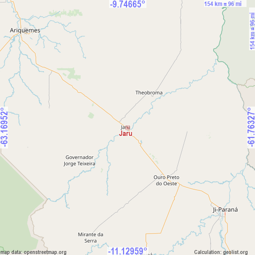
Jaru GPS coordinates[2]
10° 26' 20.004" South, 62° 27' 59.004" West
| Map corner | latitude | longitude |
|---|---|---|
| Upper-left | -9.74665°, | -63.16952° |
| Center: | -10.43889°, | -62.46639° |
| Lower-right: | -11.12959°, | -61.76327° |
| Map W x H: | 153.8×153.8 km | = 95.6×95.6mi |
| max Lat: | 2.81972° ⇑33.2% North |
| Jaru: | -10.43889° |
| min Lat: | ⇓66.8% South -33.69111° |
| min Long | Jaru | max Long |
| -72.89583° | -62.46639° | -32.41083° |
| W 1.9%⇐ | ⇒98.1% E |
Elevation
Elevation of Jaru is 159 m = 522 ft, and this is 221.9 m = 728 ft below average elevation for this country.
| Max E: |
1603 m = 5259 ft | 66% |
| Avg. | 380.9 m = 1250 ft | |
| Jaru | 159 m = 522 ft | |
Min E: |
0 m = 0 ft | 34% |
See also: Brazil elevation on elevation.city.
Geographical zone
Jaru is located in South Torrid zone (between Equator and Tropic of Capricorn). Distance of Equator is 1160.7 km =721.2 mi to North.| Distance of | km | miles | from Jaru |
|---|---|---|---|
| Equator | 1160.7 | 721.2 | to North |
| Tropic Capricorn | 1445.2 | 898 | to South |
| Antarctic Circle | 6240.5 | 3877.7 | to South |
| South Pole | 8846.4 | 5496.9 | to South |


Nearby cities:
13 places around Jaru: (largest is in red/bold)
• Aripuanã
245.7 km =152.7 mi,  54°
54°
• Ariquemes
85.8 km =53.3 mi,  312°
312°
• Cacoal
157.3 km =97.7 mi,  134°
134°
• Extrema
432.2 km =268.6 mi,  279°
279°
• Guajará Mirim
315.9 km =196.3 mi,  263°
263°
• Humaitá
330.8 km =205.5 mi,  349°
349°
• Ji Paraná
75 km =46.6 mi, 131°
• Ouro Preto do Oeste
44 km =27.3 mi,  141°
141°
• Pimenta Bueno
195.2 km =121.3 mi, 134°
• Porto Velho
244.1 km =151.7 mi,  319°
319°
• Presidente Médici
102.5 km =63.7 mi, 142°
• Pôsto Fiscal Rolim de Moura
294.7 km =183.1 mi,  175°
175°
• Vilhena
359.7 km =223.5 mi, 135°
Sources, notices
• [Note1] Compared only with cities in Brazil existing in our database
• [Src1] Map data: © OpenStreetMap contributors (CC-BY-SA)
• [Src2] Other city data from geonames.org with taken over terms of usage.
• [Src3] Geographical zone / Annual Mean Temperature by Robert A. Rohde @ Wikipedia
