Letlhakeng geodata
Letlhakeng (Kweneng) is a populated place; located in Botswana in Africa/Gaborone (GMT+2) time zone. With population of 6,781 people, there are 23 cities with bigger population in this country. Compared to other cities in Botswana, 65.7% of cities are located further ↑North; 72.4% of cities are located further →East and 71.4% of cities have lower elevation than Letlhakeng. Note1


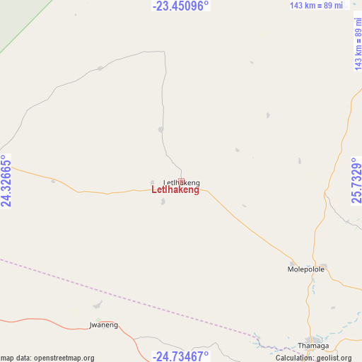
Letlhakeng GPS coordinates[2]
24° 5' 39.912" South, 25° 1' 47.172" East
| Map corner | latitude | longitude |
|---|---|---|
| Upper-left | -23.45096°, | 24.32665° |
| Center: | -24.09442°, | 25.02977° |
| Lower-right: | -24.73467°, | 25.7329° |
| Map W x H: | 142.7×142.7 km | = 88.7×88.7mi |
| max Lat: | -17.80165° ⇑65.7% North |
| Letlhakeng: | -24.09442° |
| min Lat: | ⇓34.3% South -26.9° |
| min Long | Letlhakeng | max Long |
| 20.06667° | 25.02977° | 28.74946° |
| W 27.6%⇐ | ⇒72.4% E |
Elevation
Elevation of Letlhakeng is 1075 m = 3527 ft, and this is 60 m = 197 ft above average elevation for this country.
| Max E: |
1406 m = 4613 ft | 28.6% |
| Letlhakeng | 1075 m 3527 ft | |
| Avg. | 1015 m = 3330 ft | |
Min E: |
676 m = 2218 ft | 71.4% |
See also: Botswana elevation on elevation.city.
Geographical zone
Letlhakeng is located in South temperate zone (between Tropic of Capricorn and the Antarctic Circle). Distance of this Southern Tropic circle is 73.1 km =45.4 mi to North.| Distance of | km | miles | from Letlhakeng |
|---|---|---|---|
| Equator | 2679 | 1664.7 | to North |
| Tropic Capricorn | 73.1 | 45.4 | to North |
| Antarctic Circle | 4722.1 | 2934.2 | to South |
| South Pole | 7328 | 4553.4 | to South |


Nearby cities:
15 places around Letlhakeng: (largest is in red/bold)
• Boatlaname
98.5 km =61.2 mi,  56°
56°
• Botlhapatlou
47.3 km =29.4 mi,  80°
80°
• Gabane
99.3 km =61.7 mi,  129°
129°
• Galekgatshwane
91.9 km =57.1 mi,  120°
120°
• Gaphatshwe
97.4 km =60.5 mi, 123°
• Jwaneng
64.1 km =39.8 mi,  208°
208°
• Khudumelapye
36.9 km =22.9 mi,  309°
309°
• Kopong
96.7 km =60.1 mi, 116°
• Lenchwe Le Tau
89.1 km =55.4 mi,  111°
111°
• Metsemotlhaba
93.4 km =58 mi, 122°
• Mmopone
100.4 km =62.4 mi, 121°
• Molepolole
58.6 km =36.4 mi, 126°
• Mononyane
90.1 km =56 mi, 123°
• Mosopa
85.1 km =52.9 mi,  152°
152°
• Thamaga
82.3 km =51.1 mi,  141°
141°
Sources, notices
• [Note1] Compared only with cities in Botswana existing in our database
• [Src1] Map data: © OpenStreetMap contributors (CC-BY-SA)
• [Src2] Other city data from geonames.org with taken over terms of usage.
• [Src3] Geographical zone / Annual Mean Temperature by Robert A. Rohde @ Wikipedia
