Jwaneng geodata
Jwaneng is a seat of a first-order administrative division; located in Botswana in Africa/Gaborone (GMT+2) time zone. In our database, there are 105 cities with bigger population. Compared to other cities in Botswana, 81.9% of cities are located further ↑North; 75.2% of cities are located further →East and 93.3% of cities have lower elevation than Jwaneng. Note1


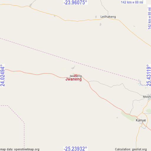
Jwaneng GPS coordinates[2]
24° 36' 6.012" South, 24° 43' 41.016" East
| Map corner | latitude | longitude |
|---|---|---|
| Upper-left | -23.96075°, | 24.02494° |
| Center: | -24.60167°, | 24.72806° |
| Lower-right: | -25.23932°, | 25.43119° |
| Map W x H: | 142.2×142.2 km | = 88.4×88.4mi |
| max Lat: | -17.80165° ⇑81.9% North |
| Jwaneng: | -24.60167° |
| min Lat: | ⇓18.1% South -26.9° |
| min Long | Jwaneng | max Long |
| 20.06667° | 24.72806° | 28.74946° |
| W 24.8%⇐ | ⇒75.2% E |
Elevation
Elevation of Jwaneng is 1198 m = 3930 ft, and this is 183 m = 600 ft above average elevation for this country.
| Max E: |
1406 m = 4613 ft | 6.7% |
| Jwaneng | 1198 m 3930 ft | |
| Avg. | 1015 m = 3330 ft | |
Min E: |
676 m = 2218 ft | 93.3% |
See also: Botswana elevation on elevation.city.
Geographical zone
Jwaneng is located in South temperate zone (between Tropic of Capricorn and the Antarctic Circle). Distance of this Southern Tropic circle is 129.5 km =80.5 mi to North.| Distance of | km | miles | from Jwaneng |
|---|---|---|---|
| Equator | 2735.4 | 1699.7 | to North |
| Tropic Capricorn | 129.5 | 80.5 | to North |
| Antarctic Circle | 4665.7 | 2899.1 | to South |
| South Pole | 7271.6 | 4518.4 | to South |


Nearby cities:
15 places around Jwaneng: (largest is in red/bold)
• Botlhapatlou
100.3 km =62.3 mi,  50°
50°
• Dutlwe
108.5 km =67.4 mi,  309°
309°
• Gabane
106.8 km =66.4 mi,  93°
93°
• Galekgatshwane
109.5 km =68 mi, 85°
• Kanye
73.3 km =45.5 mi,  123°
123°
• Khudumelapye
79.9 km =49.6 mi,  1°
1°
• Letlhakeng
64.1 km =39.8 mi,  28°
28°
• Metsemotlhaba
108.8 km =67.6 mi, 87°
• Mmokolodi
108.9 km =67.7 mi,  95°
95°
• Molepolole
80.6 km =50.1 mi,  74°
74°
• Mononyane
105.7 km =65.7 mi, 86°
• Mosopa
72.6 km =45.1 mi,  105°
105°
• Otse
111.5 km =69.3 mi, 114°
• Sekoma
88.4 km =54.9 mi,  284°
284°
• Thamaga
82.4 km =51.2 mi, 95°
Sources, notices
• [Note1] Compared only with cities in Botswana existing in our database
• [Src1] Map data: © OpenStreetMap contributors (CC-BY-SA)
• [Src2] Other city data from geonames.org with taken over terms of usage.
• [Src3] Geographical zone / Annual Mean Temperature by Robert A. Rohde @ Wikipedia
