Port Stanley geodata
Port Stanley (Ontario) is a populated place; located in Canada in America/Toronto (GMT-4) time zone. With population of 2,148 people, there are 726 cities with bigger population in this country. Compared to other cities in Canada, 99.2% of cities are located further ↑North; 59.8% of cities are located further →East and 51.8% of cities have lower elevation than Port Stanley. Note1


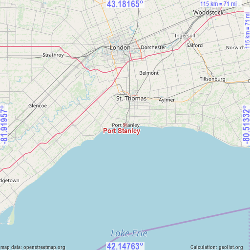
Port Stanley GPS coordinates[2]
42° 40' 0.444" North, 81° 12' 59.184" West
| Map corner | latitude | longitude |
|---|---|---|
| Upper-left | 43.18165°, | -81.91957° |
| Center: | 42.66679°, | -81.21644° |
| Lower-right: | 42.14763°, | -80.51332° |
| Map W x H: | 115×115 km | = 71.5×71.5mi |
| max Lat: | 73.03752° ⇑99.2% North |
| Port Stanley: | 42.66679° |
| min Lat: | ⇓0.8% South 42.05009° |
| min Long | Port Stanley | max Long |
| -139.43328° | -81.21644° | -52.70931° |
| W 40.2%⇐ | ⇒59.8% E |
Elevation
Elevation of Port Stanley is 180 m = 591 ft, and this is 74.4 m = 244 ft below average elevation for this country.
| Max E: |
1518 m = 4980 ft | 48.2% |
| Avg. | 254.4 m = 835 ft | |
| Port Stanley | 180 m = 591 ft | |
Min E: |
-2 m = -7 ft | 51.8% |
See also: Canada elevation on elevation.city.
Geographical zone
Port Stanley is located in North temperate zone (between Tropic of Cancer and the Arctic Circle). Distance of this Northern Tropic circle is 2138.2 km =1328.6 mi to South.| Distance of | km | miles | from Port Stanley |
|---|---|---|---|
| North Pole | 5263 | 3270.3 | to North |
| Arctic Circle | 2657.1 | 1651 | to North |
| Tropic Cancer | 2138.2 | 1328.6 | to South |
| Equator | 4744.1 | 2947.8 | to South |


Nearby cities:
15 places around Port Stanley: (largest is in red/bold)
• Aylmer
22.1 km =13.7 mi,  59°
59°
• Belmont
26.4 km =16.4 mi,  24°
24°
• Bothwell
53.3 km =33.1 mi,  266°
266°
• Delaware
32.2 km =20 mi,  329°
329°
• Dorchester
37.3 km =23.2 mi, 19°
• Glencoe
41.9 km =26 mi,  282°
282°
• Ingersoll
49 km =30.4 mi,  33°
33°
• London
35.2 km =21.9 mi,  357°
357°
• Lucan
59.3 km =36.8 mi,  345°
345°
• Mount Brydges
33.9 km =21.1 mi,  320°
320°
• Port Rowan
61.6 km =38.3 mi,  95°
95°
• Ridgetown
61.7 km =38.3 mi,  245°
245°
• St. Thomas
12.2 km =7.6 mi,  13°
13°
• Watford
62.8 km =39 mi,  300°
300°
• West Lorne
32.2 km =20 mi,  256°
256°
Sources, notices
• [Note1] Compared only with cities in Canada existing in our database
• [Src1] Map data: © OpenStreetMap contributors (CC-BY-SA)
• [Src2] Other city data from geonames.org with taken over terms of usage.
• [Src3] Geographical zone / Annual Mean Temperature by Robert A. Rohde @ Wikipedia
