Delaware geodata
Delaware (Ontario) is a populated locality; located in Canada in America/Toronto (GMT-4) time zone. With population of 2,521 people, there are 672 cities with bigger population in this country. Compared to other cities in Canada, 98% of cities are located further ↑North; 60.7% of cities are located further →East and 58.6% of cities have lower elevation than Delaware. Note1


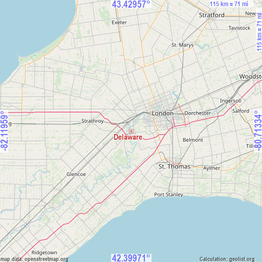
Delaware GPS coordinates[2]
42° 55' 0.444" North, 81° 24' 59.256" West
| Map corner | latitude | longitude |
|---|---|---|
| Upper-left | 43.42957°, | -82.11959° |
| Center: | 42.91679°, | -81.41646° |
| Lower-right: | 42.39971°, | -80.71334° |
| Map W x H: | 114.5×114.5 km | = 71.1×71.1mi |
| max Lat: | 73.03752° ⇑98% North |
| Delaware: | 42.91679° |
| min Lat: | ⇓2% South 42.05009° |
| min Long | Delaware | max Long |
| -139.43328° | -81.41646° | -52.70931° |
| W 39.3%⇐ | ⇒60.7% E |
Elevation
Elevation of Delaware is 222 m = 728 ft, and this is 32.4 m = 106 ft below average elevation for this country.
| Max E: |
1518 m = 4980 ft | 41.4% |
| Avg. | 254.4 m = 835 ft | |
| Delaware | 222 m = 728 ft | |
Min E: |
-2 m = -7 ft | 58.6% |
See also: Canada elevation on elevation.city.
Geographical zone
Delaware is located in North temperate zone (between Tropic of Cancer and the Arctic Circle). Distance of this Northern Tropic circle is 2166 km =1345.9 mi to South.| Distance of | km | miles | from Delaware |
|---|---|---|---|
| North Pole | 5235.2 | 3253 | to North |
| Arctic Circle | 2629.3 | 1633.8 | to North |
| Tropic Cancer | 2166 | 1345.9 | to South |
| Equator | 4771.9 | 2965.1 | to South |


Nearby cities:
15 places around Delaware: (largest is in red/bold)
• Aylmer
39.1 km =24.3 mi,  115°
115°
• Belmont
27.4 km =17 mi,  97°
97°
• Bothwell
48.4 km =30.1 mi,  229°
229°
• Dorchester
29.4 km =18.3 mi,  75°
75°
• Glencoe
30.7 km =19.1 mi, 232°
• Ingersoll
45.3 km =28.1 mi,  73°
73°
• London
16.7 km =10.4 mi,  63°
63°
• Lucan
29.7 km =18.5 mi,  2°
2°
• Mount Brydges
5.7 km =3.5 mi,  251°
251°
• Parkhill
34.7 km =21.6 mi,  321°
321°
• Port Stanley
32.2 km =20 mi,  149°
149°
• South Huron
45.2 km =28.1 mi,  349°
349°
• St. Thomas
25 km =15.5 mi,  129°
129°
• Watford
38.2 km =23.7 mi,  275°
275°
• West Lorne
38.3 km =23.8 mi,  203°
203°
Sources, notices
• [Note1] Compared only with cities in Canada existing in our database
• [Src1] Map data: © OpenStreetMap contributors (CC-BY-SA)
• [Src2] Other city data from geonames.org with taken over terms of usage.
• [Src3] Geographical zone / Annual Mean Temperature by Robert A. Rohde @ Wikipedia
