Goulds geodata
Goulds (Newfoundland and Labrador) is a populated place; located in Canada in America/St_Johns (GMT-2.5) time zone. With population of 4,418 people, there are 507 cities with bigger population in this country. Compared to other cities in Canada, 50.3% of cities are located further ↓South; 99.8% of cities are located further ←West and 62.9% of cities have higher elevation than Goulds. Note1


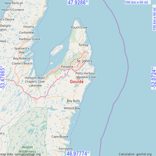
Goulds GPS coordinates[2]
47° 27' 19.152" North, 52° 46' 31.872" West
| Map corner | latitude | longitude |
|---|---|---|
| Upper-left | 47.9286°, | -53.47865° |
| Center: | 47.45532°, | -52.77552° |
| Lower-right: | 46.97774°, | -52.0724° |
| Map W x H: | 105.7×105.7 km | = 65.7×65.7mi |
| max Lat: | 73.03752° ⇑49.7% North |
| Goulds: | 47.45532° |
| min Lat: | ⇓50.3% South 42.05009° |
| min Long | Goulds | max Long |
| -139.43328° | -52.77552° | -52.70931° |
| W 99.8%⇐ | ⇒0.2% E |
Elevation
Elevation of Goulds is 87 m = 285 ft, and this is 167.4 m = 549 ft below average elevation for this country.
| Max E: |
1518 m = 4980 ft | 62.9% |
| Avg. | 254.4 m = 835 ft | |
| Goulds | 87 m = 285 ft | |
Min E: |
-2 m = -7 ft | 37.1% |
See also: Canada elevation on elevation.city.
Geographical zone
Goulds is located in North temperate zone (between Tropic of Cancer and the Arctic Circle). Distance of this North polar circle is 2124.6 km =1320.2 mi to North.| Distance of | km | miles | from Goulds |
|---|---|---|---|
| North Pole | 4730.5 | 2939.4 | to North |
| Arctic Circle | 2124.6 | 1320.2 | to North |
| Tropic Cancer | 2670.6 | 1659.4 | to South |
| Equator | 5276.5 | 3278.7 | to South |


Nearby cities:
15 places around Goulds: (largest is in red/bold)
• Bay Roberts
40.1 km =24.9 mi,  293°
293°
• Blaketown
59.4 km =36.9 mi,  272°
272°
• Bloomfield
132.8 km =82.5 mi,  320°
320°
• Bonavista
135.2 km =84 mi,  349°
349°
• Carbonear
45.2 km =28.1 mi,  313°
313°
• Catalina
120.2 km =74.7 mi, 349°
• Clarenville-Shoal Harbour
120.2 km =74.7 mi, 312°
• Conception Bay South
17.4 km =10.8 mi, 286°
• Green's Harbour
57.7 km =35.9 mi, 290°
• Hare Bay
180.3 km =112 mi,  329°
329°
• Mount Pearl
6.8 km =4.2 mi,  356°
356°
• St. John's
13.2 km =8.2 mi,  22°
22°
• Torbay
23.7 km =14.7 mi,  8°
8°
• Upper Island Cove
39.4 km =24.5 mi,  303°
303°
• Wabana
23.6 km =14.7 mi, 326°
Sources, notices
• [Note1] Compared only with cities in Canada existing in our database
• [Src1] Map data: © OpenStreetMap contributors (CC-BY-SA)
• [Src2] Other city data from geonames.org with taken over terms of usage.
• [Src3] Geographical zone / Annual Mean Temperature by Robert A. Rohde @ Wikipedia
