Cranberry Portage geodata
Cranberry Portage (Manitoba) is a populated place; located in Canada in America/Winnipeg (GMT-5) time zone. With population of 771 people, there are 1105 cities with bigger population in this country. Compared to other cities in Canada, 94.5% of cities are located further ↓South; 69.4% of cities are located further →East and 70% of cities have lower elevation than Cranberry Portage. Note1


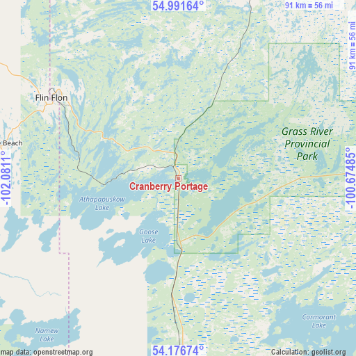
Cranberry Portage GPS coordinates[2]
54° 35' 10.428" North, 101° 22' 40.692" West
| Map corner | latitude | longitude |
|---|---|---|
| Upper-left | 54.99164°, | -102.0811° |
| Center: | 54.58623°, | -101.37797° |
| Lower-right: | 54.17674°, | -100.67485° |
| Map W x H: | 90.6×90.6 km | = 56.3×56.3mi |
| max Lat: | 73.03752° ⇑5.5% North |
| Cranberry Portage: | 54.58623° |
| min Lat: | ⇓94.5% South 42.05009° |
| min Long | Cranberry Porta | max Long |
| -139.43328° | -101.37797° | -52.70931° |
| W 30.6%⇐ | ⇒69.4% E |
Elevation
Elevation of Cranberry Portage is 305 m = 1001 ft, and this is 50.6 m = 166 ft above average elevation for this country.
| Max E: |
1518 m = 4980 ft | 30% |
| Cranberry Portage | 305 m 1001 ft | |
| Avg. | 254.4 m = 835 ft | |
Min E: |
-2 m = -7 ft | 70% |
See also: Canada elevation on elevation.city.
Geographical zone
Cranberry Portage is located in North temperate zone (between Tropic of Cancer and the Arctic Circle). Distance of this North polar circle is 1331.8 km =827.5 mi to North.| Distance of | km | miles | from Cranberry Portage |
|---|---|---|---|
| North Pole | 3937.6 | 2446.7 | to North |
| Arctic Circle | 1331.8 | 827.5 | to North |
| Tropic Cancer | 3463.5 | 2152.1 | to South |
| Equator | 6069.4 | 3771.3 | to South |


Nearby cities:
15 places around Cranberry Portage: (largest is in red/bold)
• Camperville
300.3 km =186.6 mi,  164°
164°
• Carrot River
204.5 km =127.1 mi,  224°
224°
• Cross Lake 19A
232.5 km =144.5 mi,  88°
88°
• Flin Flon
37.7 km =23.4 mi,  302°
302°
• Hudson Bay
204.1 km =126.8 mi,  198°
198°
• Kelvington
304.7 km =189.3 mi,  207°
207°
• La Ronge
256.5 km =159.4 mi,  282°
282°
• Melfort
286.3 km =177.9 mi,  228°
228°
• Nipawin
218.6 km =135.8 mi, 231°
• Pelican Narrows
118.6 km =73.7 mi, 302°
• Preeceville
305.4 km =189.8 mi, 196°
• Swan River
275.9 km =171.4 mi,  178°
178°
• The Pas
85 km =52.8 mi,  174°
174°
• Thompson
258 km =160.3 mi,  60°
60°
• Tisdale
261.1 km =162.2 mi, 222°
Sources, notices
• [Note1] Compared only with cities in Canada existing in our database
• [Src1] Map data: © OpenStreetMap contributors (CC-BY-SA)
• [Src2] Other city data from geonames.org with taken over terms of usage.
• [Src3] Geographical zone / Annual Mean Temperature by Robert A. Rohde @ Wikipedia
