Hudson Bay geodata
Hudson Bay (Saskatchewan) is a populated place; located in Canada in America/Regina (GMT-6) time zone. With population of 1,661 people, there are 821 cities with bigger population in this country. Compared to other cities in Canada, 88.7% of cities are located further ↓South; 70.1% of cities are located further →East and 76.4% of cities have lower elevation than Hudson Bay. Note1


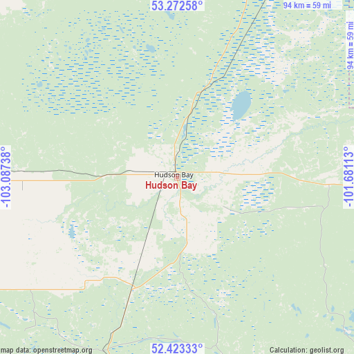
Hudson Bay GPS coordinates[2]
52° 51' 0.108" North, 102° 23' 3.3" West
| Map corner | latitude | longitude |
|---|---|---|
| Upper-left | 53.27258°, | -103.08738° |
| Center: | 52.85003°, | -102.38425° |
| Lower-right: | 52.42333°, | -101.68113° |
| Map W x H: | 94.4×94.4 km | = 58.7×58.7mi |
| max Lat: | 73.03752° ⇑11.3% North |
| Hudson Bay: | 52.85003° |
| min Lat: | ⇓88.7% South 42.05009° |
| min Long | Hudson Bay | max Long |
| -139.43328° | -102.38425° | -52.70931° |
| W 29.9%⇐ | ⇒70.1% E |
Elevation
Elevation of Hudson Bay is 375 m = 1230 ft, and this is 120.6 m = 396 ft above average elevation for this country.
| Max E: |
1518 m = 4980 ft | 23.6% |
| Hudson Bay | 375 m 1230 ft | |
| Avg. | 254.4 m = 835 ft | |
Min E: |
-2 m = -7 ft | 76.4% |
See also: Canada elevation on elevation.city.
Geographical zone
Hudson Bay is located in North temperate zone (between Tropic of Cancer and the Arctic Circle). Distance of this North polar circle is 1524.8 km =947.5 mi to North.| Distance of | km | miles | from Hudson Bay |
|---|---|---|---|
| North Pole | 4130.7 | 2566.7 | to North |
| Arctic Circle | 1524.8 | 947.5 | to North |
| Tropic Cancer | 3270.5 | 2032.2 | to South |
| Equator | 5876.4 | 3651.4 | to South |


Nearby cities:
15 places around Hudson Bay: (largest is in red/bold)
• Camperville
179.6 km =111.6 mi,  122°
122°
• Canora
135.3 km =84.1 mi,  181°
181°
• Carrot River
93.5 km =58.1 mi,  301°
301°
• Foam Lake
154.7 km =96.1 mi,  210°
210°
• Kamsack
146.4 km =91 mi,  167°
167°
• Kelvington
108.8 km =67.6 mi,  225°
225°
• Melfort
149.9 km =93.1 mi,  270°
270°
• Nipawin
122.2 km =75.9 mi, 298°
• Preeceville
101.9 km =63.3 mi,  190°
190°
• Swan River
112.1 km =69.7 mi,  137°
137°
• The Pas
131.8 km =81.9 mi,  34°
34°
• Tisdale
111.9 km =69.5 mi, 269°
• Wadena
138.8 km =86.2 mi,  223°
223°
• Wynyard
171.7 km =106.7 mi, 225°
• Yorkton
181.7 km =112.9 mi, 181°
Sources, notices
• [Note1] Compared only with cities in Canada existing in our database
• [Src1] Map data: © OpenStreetMap contributors (CC-BY-SA)
• [Src2] Other city data from geonames.org with taken over terms of usage.
• [Src3] Geographical zone / Annual Mean Temperature by Robert A. Rohde @ Wikipedia
