La Ronge geodata
La Ronge (Saskatchewan) is a populated place; located in Canada in America/Regina (GMT-6) time zone. With population of 5,671 people, there are 443 cities with bigger population in this country. Compared to other cities in Canada, 95.2% of cities are located further ↓South; 72.3% of cities are located further →East and 75% of cities have lower elevation than La Ronge. Note1


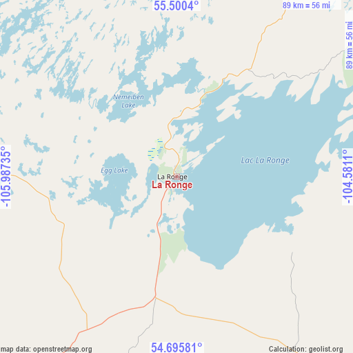
La Ronge GPS coordinates[2]
55° 6' 0.468" North, 105° 17' 3.192" West
| Map corner | latitude | longitude |
|---|---|---|
| Upper-left | 55.5004°, | -105.98735° |
| Center: | 55.10013°, | -105.28422° |
| Lower-right: | 54.69581°, | -104.5811° |
| Map W x H: | 89.5×89.5 km | = 55.6×55.6mi |
| max Lat: | 73.03752° ⇑4.8% North |
| La Ronge: | 55.10013° |
| min Lat: | ⇓95.2% South 42.05009° |
| min Long | La Ronge | max Long |
| -139.43328° | -105.28422° | -52.70931° |
| W 27.7%⇐ | ⇒72.3% E |
Elevation
Elevation of La Ronge is 360 m = 1181 ft, and this is 105.6 m = 346 ft above average elevation for this country.
| Max E: |
1518 m = 4980 ft | 25% |
| La Ronge | 360 m 1181 ft | |
| Avg. | 254.4 m = 835 ft | |
Min E: |
-2 m = -7 ft | 75% |
See also: Canada elevation on elevation.city.
Geographical zone
La Ronge is located in North temperate zone (between Tropic of Cancer and the Arctic Circle). Distance of this North polar circle is 1274.6 km =792 mi to North.| Distance of | km | miles | from La Ronge |
|---|---|---|---|
| North Pole | 3880.5 | 2411.2 | to North |
| Arctic Circle | 1274.6 | 792 | to North |
| Tropic Cancer | 3520.6 | 2187.6 | to South |
| Equator | 6126.6 | 3806.9 | to South |


Nearby cities:
15 places around La Ronge: (largest is in red/bold)
• Carrot River
230.3 km =143.1 mi,  151°
151°
• Cranberry Portage
256.5 km =159.4 mi,  102°
102°
• Dalmeny
322.7 km =200.5 mi,  197°
197°
• Flin Flon
220.9 km =137.3 mi, 99°
• Hudson Bay
313.9 km =195 mi,  142°
142°
• Humboldt
322.6 km =200.5 mi,  178°
178°
• Meadow Lake
229.5 km =142.6 mi,  242°
242°
• Melfort
252.1 km =156.6 mi,  170°
170°
• Nipawin
210 km =130.5 mi,  156°
156°
• Pelican Narrows
149.6 km =93 mi,  87°
87°
• Prince Albert
213.6 km =132.7 mi,  188°
188°
• Rosthern
279.2 km =173.5 mi, 194°
• Shellbrook
221.7 km =137.8 mi, 199°
• Tisdale
262.9 km =163.4 mi, 162°
• Warman
320.8 km =199.3 mi, 195°
Sources, notices
• [Note1] Compared only with cities in Canada existing in our database
• [Src1] Map data: © OpenStreetMap contributors (CC-BY-SA)
• [Src2] Other city data from geonames.org with taken over terms of usage.
• [Src3] Geographical zone / Annual Mean Temperature by Robert A. Rohde @ Wikipedia
