The Pas geodata
The Pas (Manitoba) is a populated place; located in Canada in America/Winnipeg (GMT-5) time zone. With population of 6,055 people, there are 430 cities with bigger population in this country. Compared to other cities in Canada, 92.6% of cities are located further ↓South; 69.1% of cities are located further →East and 66.6% of cities have lower elevation than The Pas. Note1


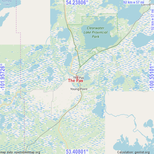
The Pas GPS coordinates[2]
53° 49' 30.324" North, 101° 15' 14.868" West
| Map corner | latitude | longitude |
|---|---|---|
| Upper-left | 54.23806°, | -101.95726° |
| Center: | 53.82509°, | -101.25413° |
| Lower-right: | 53.40801°, | -100.55101° |
| Map W x H: | 92.3×92.3 km | = 57.4×57.4mi |
| max Lat: | 73.03752° ⇑7.4% North |
| The Pas: | 53.82509° |
| min Lat: | ⇓92.6% South 42.05009° |
| min Long | The Pas | max Long |
| -139.43328° | -101.25413° | -52.70931° |
| W 30.9%⇐ | ⇒69.1% E |
Elevation
Elevation of The Pas is 267 m = 876 ft, and this is 12.6 m = 41 ft above average elevation for this country.
| Max E: |
1518 m = 4980 ft | 33.4% |
| The Pas | 267 m 876 ft | |
| Avg. | 254.4 m = 835 ft | |
Min E: |
-2 m = -7 ft | 66.6% |
See also: Canada elevation on elevation.city.
Geographical zone
The Pas is located in North temperate zone (between Tropic of Cancer and the Arctic Circle). Distance of this North polar circle is 1416.4 km =880.1 mi to North.| Distance of | km | miles | from The Pas |
|---|---|---|---|
| North Pole | 4022.3 | 2499.3 | to North |
| Arctic Circle | 1416.4 | 880.1 | to North |
| Tropic Cancer | 3378.9 | 2099.6 | to South |
| Equator | 5984.8 | 3718.8 | to South |


Nearby cities:
15 places around The Pas: (largest is in red/bold)
• Camperville
217.4 km =135.1 mi,  159°
159°
• Canora
256.3 km =159.3 mi,  198°
198°
• Carrot River
165.3 km =102.7 mi,  248°
248°
• Cranberry Portage
85 km =52.8 mi,  354°
354°
• Cross Lake 19A
244.4 km =151.9 mi,  67°
67°
• Flin Flon
112.2 km =69.7 mi,  338°
338°
• Hudson Bay
131.8 km =81.9 mi,  214°
214°
• Kamsack
254.9 km =158.4 mi,  189°
189°
• Kelvington
239.3 km =148.7 mi,  219°
219°
• Melfort
247.4 km =153.7 mi,  244°
244°
• Nipawin
188.3 km =117 mi, 254°
• Pelican Narrows
184.5 km =114.6 mi,  323°
323°
• Preeceville
229 km =142.3 mi, 204°
• Swan River
191.2 km =118.8 mi,  180°
180°
• Tisdale
215 km =133.6 mi, 239°
Sources, notices
• [Note1] Compared only with cities in Canada existing in our database
• [Src1] Map data: © OpenStreetMap contributors (CC-BY-SA)
• [Src2] Other city data from geonames.org with taken over terms of usage.
• [Src3] Geographical zone / Annual Mean Temperature by Robert A. Rohde @ Wikipedia
