Carrot River geodata
Carrot River (Saskatchewan) is a populated place; located in Canada in America/Regina (GMT-6) time zone. With population of 950 people, there are 1063 cities with bigger population in this country. Compared to other cities in Canada, 90.2% of cities are located further ↓South; 71% of cities are located further →East and 74.7% of cities have lower elevation than Carrot River. Note1


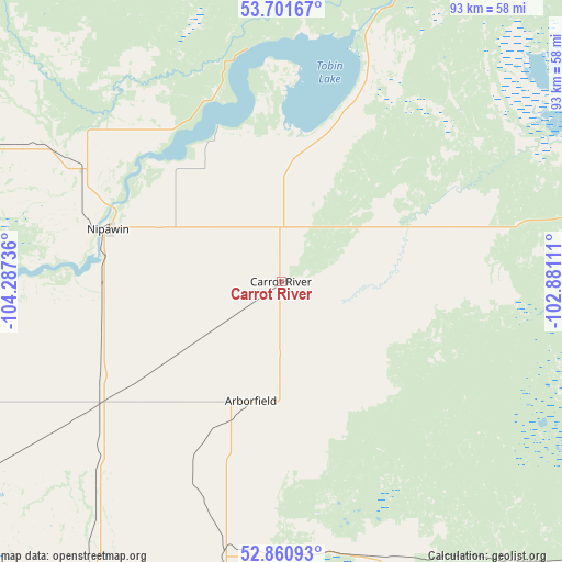
Carrot River GPS coordinates[2]
53° 17' 0.132" North, 103° 35' 3.228" West
| Map corner | latitude | longitude |
|---|---|---|
| Upper-left | 53.70167°, | -104.28736° |
| Center: | 53.28337°, | -103.58423° |
| Lower-right: | 52.86093°, | -102.88111° |
| Map W x H: | 93.5×93.5 km | = 58.1×58.1mi |
| max Lat: | 73.03752° ⇑9.8% North |
| Carrot River: | 53.28337° |
| min Lat: | ⇓90.2% South 42.05009° |
| min Long | Carrot River | max Long |
| -139.43328° | -103.58423° | -52.70931° |
| W 29%⇐ | ⇒71% E |
Elevation
Elevation of Carrot River is 358 m = 1175 ft, and this is 103.6 m = 340 ft above average elevation for this country.
| Max E: |
1518 m = 4980 ft | 25.3% |
| Carrot River | 358 m 1175 ft | |
| Avg. | 254.4 m = 835 ft | |
Min E: |
-2 m = -7 ft | 74.7% |
See also: Canada elevation on elevation.city.
Geographical zone
Carrot River is located in North temperate zone (between Tropic of Cancer and the Arctic Circle). Distance of this North polar circle is 1476.6 km =917.5 mi to North.| Distance of | km | miles | from Carrot River |
|---|---|---|---|
| North Pole | 4082.5 | 2536.7 | to North |
| Arctic Circle | 1476.6 | 917.5 | to North |
| Tropic Cancer | 3318.6 | 2062.1 | to South |
| Equator | 5924.6 | 3681.4 | to South |


Nearby cities:
15 places around Carrot River: (largest is in red/bold)
• Foam Lake
181.6 km =112.8 mi,  178°
178°
• Hudson Bay
93.5 km =58.1 mi,  121°
121°
• Humboldt
159 km =98.8 mi,  220°
220°
• Kelvington
124.2 km =77.2 mi, 178°
• Lanigan
187.1 km =116.3 mi,  211°
211°
• Melfort
83.1 km =51.6 mi,  236°
236°
• Nipawin
29.2 km =18.1 mi,  288°
288°
• Preeceville
160.6 km =99.8 mi,  157°
157°
• Prince Albert
145.6 km =90.5 mi,  266°
266°
• Rosthern
196.5 km =122.1 mi,  249°
249°
• Shellbrook
187.5 km =116.5 mi, 267°
• The Pas
165.3 km =102.7 mi,  68°
68°
• Tisdale
57.4 km =35.7 mi, 212°
• Wadena
149 km =92.6 mi,  185°
185°
• Wynyard
173.4 km =107.7 mi, 193°
Sources, notices
• [Note1] Compared only with cities in Canada existing in our database
• [Src1] Map data: © OpenStreetMap contributors (CC-BY-SA)
• [Src2] Other city data from geonames.org with taken over terms of usage.
• [Src3] Geographical zone / Annual Mean Temperature by Robert A. Rohde @ Wikipedia
