Ear Falls geodata
Ear Falls (Ontario) is a populated place; located in Canada in America/Winnipeg (GMT-5) time zone. With population of 1,026 people, there are 1036 cities with bigger population in this country. Compared to other cities in Canada, 80.2% of cities are located further ↓South; 64.6% of cities are located further →East and 76.6% of cities have lower elevation than Ear Falls. Note1


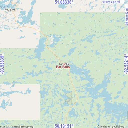
Ear Falls GPS coordinates[2]
50° 38' 22.38" North, 93° 14' 6.936" West
| Map corner | latitude | longitude |
|---|---|---|
| Upper-left | 51.08336°, | -93.93839° |
| Center: | 50.63955°, | -93.23526° |
| Lower-right: | 50.19151°, | -92.53214° |
| Map W x H: | 99.2×99.2 km | = 61.6×61.6mi |
| max Lat: | 73.03752° ⇑19.8% North |
| Ear Falls: | 50.63955° |
| min Lat: | ⇓80.2% South 42.05009° |
| min Long | Ear Falls | max Long |
| -139.43328° | -93.23526° | -52.70931° |
| W 35.4%⇐ | ⇒64.6% E |
Elevation
Elevation of Ear Falls is 376 m = 1234 ft, and this is 121.6 m = 399 ft above average elevation for this country.
| Max E: |
1518 m = 4980 ft | 23.4% |
| Ear Falls | 376 m 1234 ft | |
| Avg. | 254.4 m = 835 ft | |
Min E: |
-2 m = -7 ft | 76.6% |
See also: Canada elevation on elevation.city.
Geographical zone
Ear Falls is located in North temperate zone (between Tropic of Cancer and the Arctic Circle). Distance of this North polar circle is 1770.6 km =1100.2 mi to North.| Distance of | km | miles | from Ear Falls |
|---|---|---|---|
| North Pole | 4376.5 | 2719.4 | to North |
| Arctic Circle | 1770.6 | 1100.2 | to North |
| Tropic Cancer | 3024.7 | 1879.5 | to South |
| Equator | 5630.6 | 3498.7 | to South |


Nearby cities:
15 places around Ear Falls: (largest is in red/bold)
• Atikokan
239.3 km =148.7 mi,  151°
151°
• Beausejour
241.5 km =150.1 mi,  254°
254°
• Dryden
101.3 km =62.9 mi,  160°
160°
• Fort Frances
225.2 km =139.9 mi,  183°
183°
• Garson
254.1 km =157.9 mi,  255°
255°
• Golden
58.4 km =36.3 mi,  323°
323°
• Kenora
131.8 km =81.9 mi,  222°
222°
• Lac du Bonnet
204.6 km =127.1 mi, 257°
• Moose Lake
217.7 km =135.3 mi, 222°
• Pine Falls
210.6 km =130.9 mi,  267°
267°
• Powerview
209.3 km =130.1 mi, 267°
• Red Lake
59 km =36.7 mi, 323°
• Red Lake
59.1 km =36.7 mi, 315°
• Sioux Lookout
109.3 km =67.9 mi,  125°
125°
• Tyndall
250.6 km =155.7 mi, 255°
Sources, notices
• [Note1] Compared only with cities in Canada existing in our database
• [Src1] Map data: © OpenStreetMap contributors (CC-BY-SA)
• [Src2] Other city data from geonames.org with taken over terms of usage.
• [Src3] Geographical zone / Annual Mean Temperature by Robert A. Rohde @ Wikipedia
