Botwood geodata
Botwood (Newfoundland and Labrador) is a populated place; located in Canada in America/St_Johns (GMT-2.5) time zone. With population of 2,940 people, there are 621 cities with bigger population in this country. Compared to other cities in Canada, 64.5% of cities are located further ↓South; 98.1% of cities are located further ←West and 88.3% of cities have higher elevation than Botwood. Note1


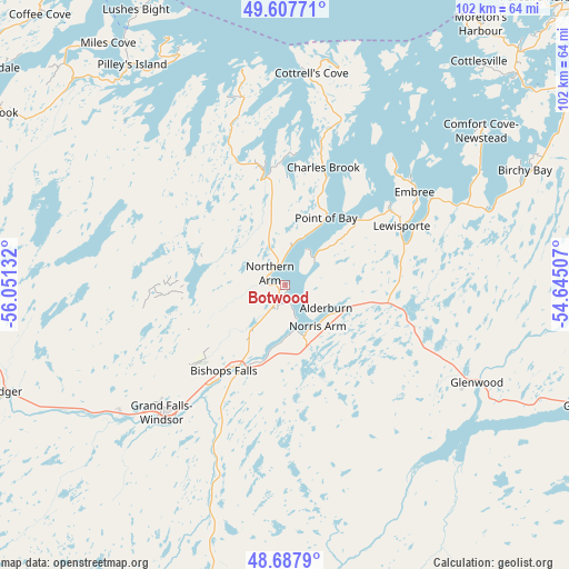
Botwood GPS coordinates[2]
49° 8' 59.784" North, 55° 20' 53.484" West
| Map corner | latitude | longitude |
|---|---|---|
| Upper-left | 49.60771°, | -56.05132° |
| Center: | 49.14994°, | -55.34819° |
| Lower-right: | 48.6879°, | -54.64507° |
| Map W x H: | 102.3×102.3 km | = 63.6×63.6mi |
| max Lat: | 73.03752° ⇑35.5% North |
| Botwood: | 49.14994° |
| min Lat: | ⇓64.5% South 42.05009° |
| min Long | Botwood | max Long |
| -139.43328° | -55.34819° | -52.70931° |
| W 98.1%⇐ | ⇒1.9% E |
Elevation
Elevation of Botwood is 17 m = 56 ft, and this is 237.4 m = 779 ft below average elevation for this country.
| Max E: |
1518 m = 4980 ft | 88.3% |
| Avg. | 254.4 m = 835 ft | |
| Botwood | 17 m = 56 ft | |
Min E: |
-2 m = -7 ft | 11.7% |
See also: Canada elevation on elevation.city.
Geographical zone
Botwood is located in North temperate zone (between Tropic of Cancer and the Arctic Circle). Distance of this North polar circle is 1936.2 km =1203.1 mi to North.| Distance of | km | miles | from Botwood |
|---|---|---|---|
| North Pole | 4542.1 | 2822.3 | to North |
| Arctic Circle | 1936.2 | 1203.1 | to North |
| Tropic Cancer | 2859 | 1776.5 | to South |
| Equator | 5465 | 3395.8 | to South |


Nearby cities:
15 places around Botwood: (largest is in red/bold)
• Bloomfield
136.2 km =84.6 mi,  128°
128°
• Bonavista
172.5 km =107.2 mi,  108°
108°
• Catalina
180.2 km =112 mi, 112°
• Clarenville-Shoal Harbour
147.9 km =91.9 mi,  136°
136°
• Deer Lake
151.5 km =94.1 mi,  270°
270°
• Fogo Island
106 km =65.9 mi,  53°
53°
• Gambo
92.2 km =57.3 mi,  116°
116°
• Gander Bay North
66.7 km =41.4 mi,  70°
70°
• Grand Falls-Windsor
33.4 km =20.8 mi,  223°
223°
• Hare Bay
102.8 km =63.9 mi, 108°
• La Scie
90.8 km =56.4 mi,  348°
348°
• Lewisporte
24.5 km =15.2 mi,  62°
62°
• Pasadena
164.5 km =102.2 mi,  264°
264°
• Springdale
64.9 km =40.3 mi,  306°
306°
• Virgin Arm-Carter's Cove
59.2 km =36.8 mi,  43°
43°
Sources, notices
• [Note1] Compared only with cities in Canada existing in our database
• [Src1] Map data: © OpenStreetMap contributors (CC-BY-SA)
• [Src2] Other city data from geonames.org with taken over terms of usage.
• [Src3] Geographical zone / Annual Mean Temperature by Robert A. Rohde @ Wikipedia
