Lewisporte geodata
Lewisporte (Newfoundland and Labrador) is a populated place; located in Canada in America/St_Johns (GMT-2.5) time zone. With population of 2,174 people, there are 722 cities with bigger population in this country. Compared to other cities in Canada, 67.1% of cities are located further ↓South; 98.3% of cities are located further ←West and 91.9% of cities have higher elevation than Lewisporte. Note1


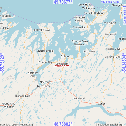
Lewisporte GPS coordinates[2]
49° 14' 59.748" North, 55° 2' 53.376" West
| Map corner | latitude | longitude |
|---|---|---|
| Upper-left | 49.70677°, | -55.75129° |
| Center: | 49.24993°, | -55.04816° |
| Lower-right: | 48.78882°, | -54.34504° |
| Map W x H: | 102.1×102.1 km | = 63.4×63.4mi |
| max Lat: | 73.03752° ⇑32.9% North |
| Lewisporte: | 49.24993° |
| min Lat: | ⇓67.1% South 42.05009° |
| min Long | Lewisporte | max Long |
| -139.43328° | -55.04816° | -52.70931° |
| W 98.3%⇐ | ⇒1.7% E |
Elevation
Elevation of Lewisporte is 12 m = 39 ft, and this is 242.4 m = 795 ft below average elevation for this country.
| Max E: |
1518 m = 4980 ft | 91.9% |
| Avg. | 254.4 m = 835 ft | |
| Lewisporte | 12 m = 39 ft | |
Min E: |
-2 m = -7 ft | 8.1% |
See also: Canada elevation on elevation.city.
Geographical zone
Lewisporte is located in North temperate zone (between Tropic of Cancer and the Arctic Circle). Distance of this North polar circle is 1925.1 km =1196.2 mi to North.| Distance of | km | miles | from Lewisporte |
|---|---|---|---|
| North Pole | 4531 | 2815.4 | to North |
| Arctic Circle | 1925.1 | 1196.2 | to North |
| Tropic Cancer | 2870.2 | 1783.5 | to South |
| Equator | 5476.1 | 3402.7 | to South |


Nearby cities:
15 places around Lewisporte: (largest is in red/bold)
• Bloomfield
128 km =79.5 mi,  138°
138°
• Bonavista
156.1 km =97 mi,  115°
115°
• Botwood
24.5 km =15.2 mi,  242°
242°
• Catalina
165.3 km =102.7 mi, 119°
• Clarenville-Shoal Harbour
142.8 km =88.7 mi,  146°
146°
• Deer Lake
173.4 km =107.7 mi,  266°
266°
• Fogo Island
82 km =51 mi,  50°
50°
• Gambo
79.9 km =49.6 mi,  130°
130°
• Gander Bay North
42.6 km =26.5 mi,  74°
74°
• Grand Falls-Windsor
57.1 km =35.5 mi,  231°
231°
• Hare Bay
87.5 km =54.4 mi, 120°
• La Scie
87.3 km =54.2 mi,  333°
333°
• Pasadena
187.3 km =116.4 mi,  262°
262°
• Springdale
78.7 km =48.9 mi,  290°
290°
• Virgin Arm-Carter's Cove
36.9 km =22.9 mi,  31°
31°
Sources, notices
• [Note1] Compared only with cities in Canada existing in our database
• [Src1] Map data: © OpenStreetMap contributors (CC-BY-SA)
• [Src2] Other city data from geonames.org with taken over terms of usage.
• [Src3] Geographical zone / Annual Mean Temperature by Robert A. Rohde @ Wikipedia
