Grand Falls-Windsor geodata
Grand Falls-Windsor (Newfoundland and Labrador) is a populated place; located in Canada in America/St_Johns (GMT-2.5) time zone. With population of 12,076 people, there are 276 cities with bigger population in this country. Compared to other cities in Canada, 61.4% of cities are located further ↓South; 97.9% of cities are located further ←West and 67.2% of cities have higher elevation than Grand Falls-Windsor. Note1


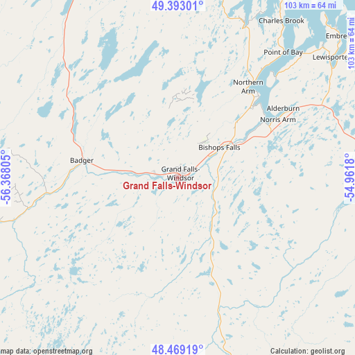
Grand Falls-Windsor GPS coordinates[2]
48° 55' 59.664" North, 55° 39' 53.712" West
| Map corner | latitude | longitude |
|---|---|---|
| Upper-left | 49.39301°, | -56.36805° |
| Center: | 48.93324°, | -55.66492° |
| Lower-right: | 48.46919°, | -54.9618° |
| Map W x H: | 102.7×102.7 km | = 63.8×63.8mi |
| max Lat: | 73.03752° ⇑38.6% North |
| Grand Falls-Windsor: | 48.93324° |
| min Lat: | ⇓61.4% South 42.05009° |
| min Long | Grand Falls-Win | max Long |
| -139.43328° | -55.66492° | -52.70931° |
| W 97.9%⇐ | ⇒2.1% E |
Elevation
Elevation of Grand Falls-Windsor is 67 m = 220 ft, and this is 187.4 m = 615 ft below average elevation for this country.
| Max E: |
1518 m = 4980 ft | 67.2% |
| Avg. | 254.4 m = 835 ft | |
| Grand Falls-Windsor | 67 m = 220 ft | |
Min E: |
-2 m = -7 ft | 32.8% |
See also: Canada elevation on elevation.city.
Geographical zone
Grand Falls-Windsor is located in North temperate zone (between Tropic of Cancer and the Arctic Circle). Distance of this North polar circle is 1960.3 km =1218.1 mi to North.| Distance of | km | miles | from Grand Falls-Windsor |
|---|---|---|---|
| North Pole | 4566.2 | 2837.3 | to North |
| Arctic Circle | 1960.3 | 1218.1 | to North |
| Tropic Cancer | 2834.9 | 1761.5 | to South |
| Equator | 5440.9 | 3380.8 | to South |


Nearby cities:
15 places around Grand Falls-Windsor: (largest is in red/bold)
• Bloomfield
143.5 km =89.2 mi,  115°
115°
• Botwood
33.4 km =20.8 mi,  43°
43°
• Clarenville-Shoal Harbour
150.2 km =93.3 mi, 123°
• Corner Brook
167 km =103.8 mi,  270°
270°
• Deer Lake
131.3 km =81.6 mi,  281°
281°
• Fogo Island
139 km =86.4 mi,  51°
51°
• Gambo
107.4 km =66.7 mi,  98°
98°
• Gander Bay North
97.8 km =60.8 mi,  61°
61°
• Harbour Breton
161.5 km =100.4 mi,  183°
183°
• Hare Bay
121 km =75.2 mi,  94°
94°
• La Scie
113.2 km =70.3 mi,  2°
2°
• Lewisporte
57.1 km =35.5 mi, 51°
• Pasadena
141.4 km =87.9 mi, 273°
• Springdale
69.4 km =43.1 mi,  335°
335°
• Virgin Arm-Carter's Cove
92.5 km =57.5 mi, 43°
Sources, notices
• [Note1] Compared only with cities in Canada existing in our database
• [Src1] Map data: © OpenStreetMap contributors (CC-BY-SA)
• [Src2] Other city data from geonames.org with taken over terms of usage.
• [Src3] Geographical zone / Annual Mean Temperature by Robert A. Rohde @ Wikipedia
