Powassan geodata
Powassan (Ontario) is a populated place; located in Canada in America/Toronto (GMT-4) time zone. With population of 1,243 people, there are 937 cities with bigger population in this country. Compared to other cities in Canada, 62.5% of cities are located further ↑North; 51.9% of cities are located further →East and 72.1% of cities have lower elevation than Powassan. Note1


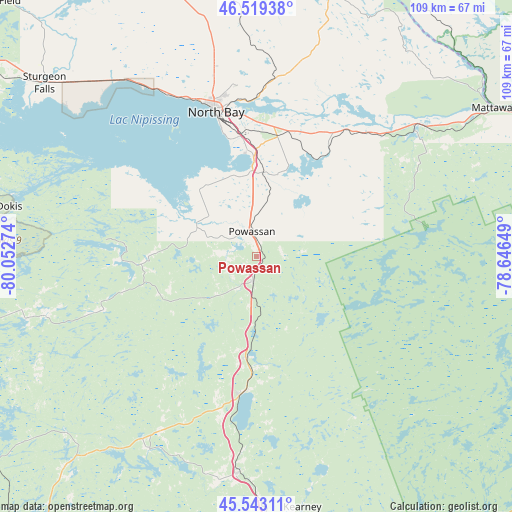
Powassan GPS coordinates[2]
46° 2' 0.24" North, 79° 20' 58.596" West
| Map corner | latitude | longitude |
|---|---|---|
| Upper-left | 46.51938°, | -80.05274° |
| Center: | 46.0334°, | -79.34961° |
| Lower-right: | 45.54311°, | -78.64649° |
| Map W x H: | 108.6×108.6 km | = 67.5×67.5mi |
| max Lat: | 73.03752° ⇑62.5% North |
| Powassan: | 46.0334° |
| min Lat: | ⇓37.5% South 42.05009° |
| min Long | Powassan | max Long |
| -139.43328° | -79.34961° | -52.70931° |
| W 48.1%⇐ | ⇒51.9% E |
Elevation
Elevation of Powassan is 330 m = 1083 ft, and this is 75.6 m = 248 ft above average elevation for this country.
| Max E: |
1518 m = 4980 ft | 27.9% |
| Powassan | 330 m 1083 ft | |
| Avg. | 254.4 m = 835 ft | |
Min E: |
-2 m = -7 ft | 72.1% |
See also: Canada elevation on elevation.city.
Geographical zone
Powassan is located in North temperate zone (between Tropic of Cancer and the Arctic Circle). Distance of this North polar circle is 2282.7 km =1418.4 mi to North.| Distance of | km | miles | from Powassan |
|---|---|---|---|
| North Pole | 4888.6 | 3037.6 | to North |
| Arctic Circle | 2282.7 | 1418.4 | to North |
| Tropic Cancer | 2512.5 | 1561.2 | to South |
| Equator | 5118.4 | 3180.4 | to South |


Nearby cities:
15 places around Powassan: (largest is in red/bold)
• Bracebridge
111.2 km =69.1 mi,  178°
178°
• Cache Bay
61.2 km =38 mi,  307°
307°
• Capreol
141.9 km =88.2 mi,  301°
301°
• Deep River
142.9 km =88.8 mi,  87°
87°
• Gravenhurst
124.2 km =77.2 mi, 180°
• Greater Sudbury
135.9 km =84.4 mi,  291°
291°
• Haliburton Village
126.8 km =78.8 mi,  149°
149°
• Huntsville
78.5 km =48.8 mi,  172°
172°
• Mattawa
59.1 km =36.7 mi,  57°
57°
• North Bay
32.8 km =20.4 mi,  344°
344°
• Notre-Dame-du-Lac
82.9 km =51.5 mi,  16°
16°
• Parry Sound
93 km =57.8 mi,  214°
214°
• South River
22.4 km =13.9 mi,  186°
186°
• Témiscaming
78.9 km =49 mi,  14°
14°
• Ville-Marie
144.7 km =89.9 mi,  357°
357°
Sources, notices
• [Note1] Compared only with cities in Canada existing in our database
• [Src1] Map data: © OpenStreetMap contributors (CC-BY-SA)
• [Src2] Other city data from geonames.org with taken over terms of usage.
• [Src3] Geographical zone / Annual Mean Temperature by Robert A. Rohde @ Wikipedia
