South River geodata
South River (Ontario) is a populated place; located in Canada in America/Toronto (GMT-4) time zone. With population of 1,193 people, there are 954 cities with bigger population in this country. Compared to other cities in Canada, 67.3% of cities are located further ↑North; 52% of cities are located further →East and 75.8% of cities have lower elevation than South River. Note1


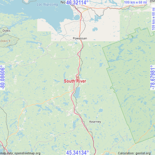
South River GPS coordinates[2]
45° 50' 0.24" North, 79° 22' 58.548" West
| Map corner | latitude | longitude |
|---|---|---|
| Upper-left | 46.32114°, | -80.08606° |
| Center: | 45.8334°, | -79.38293° |
| Lower-right: | 45.34134°, | -78.67981° |
| Map W x H: | 108.9×108.9 km | = 67.7×67.7mi |
| max Lat: | 73.03752° ⇑67.3% North |
| South River: | 45.8334° |
| min Lat: | ⇓32.7% South 42.05009° |
| min Long | South River | max Long |
| -139.43328° | -79.38293° | -52.70931° |
| W 48%⇐ | ⇒52% E |
Elevation
Elevation of South River is 369 m = 1211 ft, and this is 114.6 m = 376 ft above average elevation for this country.
| Max E: |
1518 m = 4980 ft | 24.2% |
| South River | 369 m 1211 ft | |
| Avg. | 254.4 m = 835 ft | |
Min E: |
-2 m = -7 ft | 75.8% |
See also: Canada elevation on elevation.city.
Geographical zone
South River is located in North temperate zone (between Tropic of Cancer and the Arctic Circle). Distance of this North polar circle is 2305 km =1432.3 mi to North.| Distance of | km | miles | from South River |
|---|---|---|---|
| North Pole | 4910.9 | 3051.5 | to North |
| Arctic Circle | 2305 | 1432.3 | to North |
| Tropic Cancer | 2490.3 | 1547.4 | to South |
| Equator | 5096.2 | 3166.6 | to South |


Nearby cities:
15 places around South River: (largest is in red/bold)
• Amigo Beach
126 km =78.3 mi,  180°
180°
• Bracebridge
89.1 km =55.4 mi, 176°
• Cache Bay
75.2 km =46.7 mi,  322°
322°
• Gravenhurst
101.9 km =63.3 mi, 179°
• Haliburton Village
109.8 km =68.2 mi,  142°
142°
• Huntsville
57.1 km =35.5 mi,  166°
166°
• Mattawa
75.3 km =46.8 mi,  44°
44°
• Midland
126.6 km =78.7 mi,  197°
197°
• North Bay
54.1 km =33.6 mi,  353°
353°
• Notre-Dame-du-Lac
105.1 km =65.3 mi,  14°
14°
• Orillia
136.2 km =84.6 mi, 181°
• Parry Sound
74.1 km =46 mi,  223°
223°
• Patrick Fogarty Catholic Secondary School
134.4 km =83.5 mi, 181°
• Powassan
22.4 km =13.9 mi, 6°
• Témiscaming
101.1 km =62.8 mi, 12°
Sources, notices
• [Note1] Compared only with cities in Canada existing in our database
• [Src1] Map data: © OpenStreetMap contributors (CC-BY-SA)
• [Src2] Other city data from geonames.org with taken over terms of usage.
• [Src3] Geographical zone / Annual Mean Temperature by Robert A. Rohde @ Wikipedia
