Bluewater geodata
Bluewater (Ontario) is a populated place; located in Canada in America/Toronto (GMT-4) time zone. With population of 7,044 people, there are 399 cities with bigger population in this country. Compared to other cities in Canada, 94.9% of cities are located further ↑North; 61% of cities are located further →East and 63.7% of cities have lower elevation than Bluewater. Note1


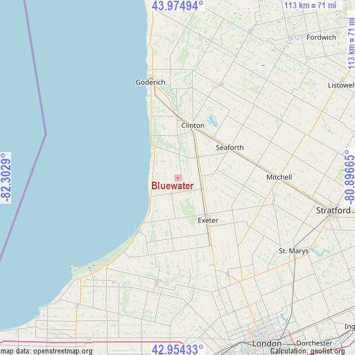
Bluewater GPS coordinates[2]
43° 28' 0.444" North, 81° 35' 59.172" West
| Map corner | latitude | longitude |
|---|---|---|
| Upper-left | 43.97494°, | -82.3029° |
| Center: | 43.46679°, | -81.59977° |
| Lower-right: | 42.95433°, | -80.89665° |
| Map W x H: | 113.5×113.5 km | = 70.5×70.5mi |
| max Lat: | 73.03752° ⇑94.9% North |
| Bluewater: | 43.46679° |
| min Lat: | ⇓5.1% South 42.05009° |
| min Long | Bluewater | max Long |
| -139.43328° | -81.59977° | -52.70931° |
| W 39%⇐ | ⇒61% E |
Elevation
Elevation of Bluewater is 249 m = 817 ft, and this is 5.4 m = 18 ft below average elevation for this country.
| Max E: |
1518 m = 4980 ft | 36.3% |
| Avg. | 254.4 m = 835 ft | |
| Bluewater | 249 m = 817 ft | |
Min E: |
-2 m = -7 ft | 63.7% |
See also: Canada elevation on elevation.city.
Geographical zone
Bluewater is located in North temperate zone (between Tropic of Cancer and the Arctic Circle). Distance of this Northern Tropic circle is 2227.1 km =1383.9 mi to South.| Distance of | km | miles | from Bluewater |
|---|---|---|---|
| North Pole | 5174 | 3215 | to North |
| Arctic Circle | 2568.1 | 1595.7 | to North |
| Tropic Cancer | 2227.1 | 1383.9 | to South |
| Equator | 4833.1 | 3003.1 | to South |


Nearby cities:
15 places around Bluewater: (largest is in red/bold)
• Brussels
40.9 km =25.4 mi,  43°
43°
• Delaware
62.9 km =39.1 mi,  166°
166°
• Goderich
31.9 km =19.8 mi,  343°
343°
• Huron East
29.4 km =18.3 mi,  55°
55°
• Lambton Shores
42.9 km =26.7 mi,  218°
218°
• Listowel
60.2 km =37.4 mi, 60°
• London
61.4 km =38.2 mi,  151°
151°
• Lucan
35.4 km =22 mi, 152°
• North Perth
58.5 km =36.4 mi, 60°
• Parkhill
34.8 km =21.6 mi,  191°
191°
• Seaforth
18.6 km =11.6 mi, 60°
• South Huron
18 km =11.2 mi,  158°
158°
• Stratford
53.7 km =33.4 mi,  101°
101°
• Watford
61.9 km =38.5 mi,  201°
201°
• Wingham
52.3 km =32.5 mi,  26°
26°
Sources, notices
• [Note1] Compared only with cities in Canada existing in our database
• [Src1] Map data: © OpenStreetMap contributors (CC-BY-SA)
• [Src2] Other city data from geonames.org with taken over terms of usage.
• [Src3] Geographical zone / Annual Mean Temperature by Robert A. Rohde @ Wikipedia
