South Huron geodata
South Huron (Ontario) is a populated place; located in Canada in America/Toronto (GMT-4) time zone. With population of 9,982 people, there are 311 cities with bigger population in this country. Compared to other cities in Canada, 95.6% of cities are located further ↑North; 60.9% of cities are located further →East and 63% of cities have lower elevation than South Huron. Note1


South Huron GPS coordinates[2]
43° 19' 0.444" North, 81° 30' 59.292" West
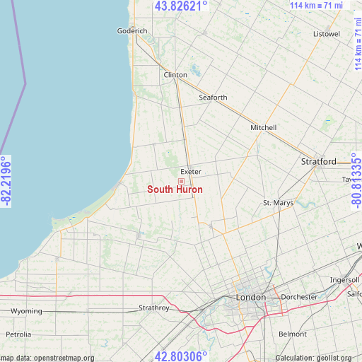
| Map corner | latitude | longitude |
|---|---|---|
| Upper-left | 43.82621°, | -82.2196° |
| Center: | 43.31679°, | -81.51647° |
| Lower-right: | 42.80306°, | -80.81335° |
| Map W x H: | 113.8×113.8 km | = 70.7×70.7mi |
| max Lat: | 73.03752° ⇑95.6% North |
| South Huron: | 43.31679° |
| min Lat: | ⇓4.4% South 42.05009° |
| min Long | South Huron | max Long |
| -139.43328° | -81.51647° | -52.70931° |
| W 39.1%⇐ | ⇒60.9% E |
Elevation
Elevation of South Huron is 246 m = 807 ft, and this is 8.4 m = 28 ft below average elevation for this country.
| Max E: |
1518 m = 4980 ft | 37% |
| Avg. | 254.4 m = 835 ft | |
| South Huron | 246 m = 807 ft | |
Min E: |
-2 m = -7 ft | 63% |
See also: Canada elevation on elevation.city.
Geographical zone
South Huron is located in North temperate zone (between Tropic of Cancer and the Arctic Circle). Distance of this Northern Tropic circle is 2210.5 km =1373.5 mi to South.| Distance of | km | miles | from South Huron |
|---|---|---|---|
| North Pole | 5190.7 | 3225.4 | to North |
| Arctic Circle | 2584.8 | 1606.1 | to North |
| Tropic Cancer | 2210.5 | 1373.5 | to South |
| Equator | 4816.4 | 2992.8 | to South |


Nearby cities:
15 places around South Huron: (largest is in red/bold)
• Bluewater
18 km =11.2 mi,  338°
338°
• Brussels
51.1 km =31.8 mi,  24°
24°
• Delaware
45.2 km =28.1 mi,  169°
169°
• Dorchester
52 km =32.3 mi,  135°
135°
• Goderich
49.8 km =30.9 mi, 341°
• Huron East
37.7 km =23.4 mi,  27°
27°
• Lambton Shores
37.6 km =23.4 mi,  243°
243°
• London
43.6 km =27.1 mi,  148°
148°
• Lucan
17.6 km =10.9 mi, 147°
• Mount Brydges
46.4 km =28.8 mi,  176°
176°
• Parkhill
22.1 km =13.7 mi,  217°
217°
• Seaforth
27.6 km =17.1 mi, 19°
• Stratford
46.2 km =28.7 mi,  83°
83°
• Tavistock
55.3 km =34.4 mi,  90°
90°
• Watford
50.5 km =31.4 mi, 216°
Sources, notices
• [Note1] Compared only with cities in Canada existing in our database
• [Src1] Map data: © OpenStreetMap contributors (CC-BY-SA)
• [Src2] Other city data from geonames.org with taken over terms of usage.
• [Src3] Geographical zone / Annual Mean Temperature by Robert A. Rohde @ Wikipedia
