Mattawa geodata
Mattawa (Ontario) is a populated place; located in Canada in America/Toronto (GMT-4) time zone. With population of 2,415 people, there are 687 cities with bigger population in this country. Compared to other cities in Canada, 57.2% of cities are located further ↑North; 51% of cities are located further ←West and 51.6% of cities have higher elevation than Mattawa. Note1


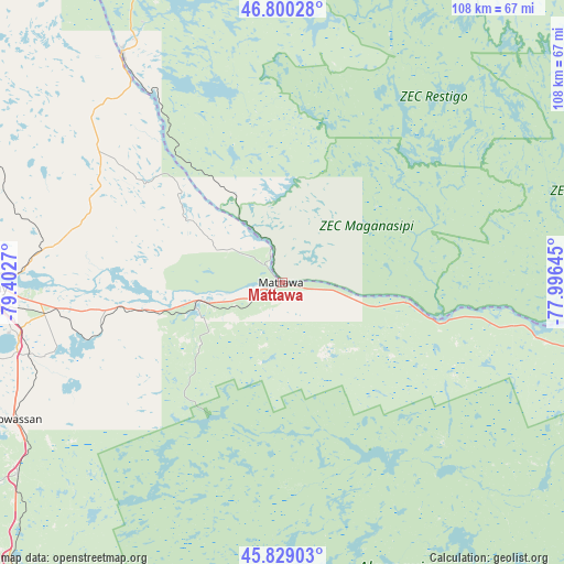
Mattawa GPS coordinates[2]
46° 19' 0.516" North, 78° 41' 58.452" West
| Map corner | latitude | longitude |
|---|---|---|
| Upper-left | 46.80028°, | -79.4027° |
| Center: | 46.31681°, | -78.69957° |
| Lower-right: | 45.82903°, | -77.99645° |
| Map W x H: | 108×108 km | = 67.1×67.1mi |
| max Lat: | 73.03752° ⇑57.2% North |
| Mattawa: | 46.31681° |
| min Lat: | ⇓42.8% South 42.05009° |
| min Long | Mattawa | max Long |
| -139.43328° | -78.69957° | -52.70931° |
| W 51%⇐ | ⇒49% E |
Elevation
Elevation of Mattawa is 161 m = 528 ft, and this is 93.4 m = 306 ft below average elevation for this country.
| Max E: |
1518 m = 4980 ft | 51.6% |
| Avg. | 254.4 m = 835 ft | |
| Mattawa | 161 m = 528 ft | |
Min E: |
-2 m = -7 ft | 48.4% |
See also: Canada elevation on elevation.city.
Geographical zone
Mattawa is located in North temperate zone (between Tropic of Cancer and the Arctic Circle). Distance of this North polar circle is 2251.2 km =1398.8 mi to North.| Distance of | km | miles | from Mattawa |
|---|---|---|---|
| North Pole | 4857.1 | 3018.1 | to North |
| Arctic Circle | 2251.2 | 1398.8 | to North |
| Tropic Cancer | 2544 | 1580.8 | to South |
| Equator | 5149.9 | 3200 | to South |


Nearby cities:
15 places around Mattawa: (largest is in red/bold)
• Cache Bay
98.7 km =61.3 mi,  273°
273°
• Deep River
95.4 km =59.3 mi,  104°
104°
• Haliburton Village
141.4 km =87.9 mi,  174°
174°
• Huntsville
116.4 km =72.3 mi,  200°
200°
• North Bay
58.9 km =36.6 mi, 269°
• Notre-Dame-du-Lac
55.1 km =34.2 mi,  330°
330°
• Parry Sound
149.4 km =92.8 mi,  223°
223°
• Pembroke
134.2 km =83.4 mi,  114°
114°
• Petawawa
119.1 km =74 mi, 113°
• Powassan
59.1 km =36.7 mi,  237°
237°
• Saint-Bruno-de-Guigues
139.5 km =86.7 mi,  336°
336°
• Saint-Isidore
132.3 km =82.2 mi, 339°
• South River
75.3 km =46.8 mi, 224°
• Témiscaming
54.3 km =33.7 mi, 325°
• Ville-Marie
126.1 km =78.4 mi, 333°
Sources, notices
• [Note1] Compared only with cities in Canada existing in our database
• [Src1] Map data: © OpenStreetMap contributors (CC-BY-SA)
• [Src2] Other city data from geonames.org with taken over terms of usage.
• [Src3] Geographical zone / Annual Mean Temperature by Robert A. Rohde @ Wikipedia
