Port McNeill geodata
Port McNeill (British Columbia) is a populated place; located in Canada in America/Vancouver (GMT-7) time zone. With population of 2,064 people, there are 740 cities with bigger population in this country. Compared to other cities in Canada, 80.1% of cities are located further ↓South; 98.7% of cities are located further →East and 81.3% of cities have higher elevation than Port McNeill. Note1
Administrative division(s):
- Level 1: British Columbia
- Level 2: Regional District of Mount Waddington
- Level 3: Port McNeill


Port McNeill GPS coordinates[2]
50° 35' 13.776" North, 127° 4' 49.908" West
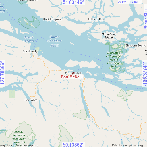
| Map corner | latitude | longitude |
|---|---|---|
| Upper-left | 51.03146°, | -127.78366° |
| Center: | 50.58716°, | -127.08053° |
| Lower-right: | 50.13862°, | -126.37741° |
| Map W x H: | 99.3×99.3 km | = 61.7×61.7mi |
| max Lat: | 73.03752° ⇑19.9% North |
| Port McNeill: | 50.58716° |
| min Lat: | ⇓80.1% South 42.05009° |
| min Long | Port McNeill | max Long |
| -139.43328° | -127.08053° | -52.70931° |
| W 1.3%⇐ | ⇒98.7% E |
Elevation
Elevation of Port McNeill is 30 m = 98 ft, and this is 224.4 m = 736 ft below average elevation for this country.
| Max E: |
1518 m = 4980 ft | 81.3% |
| Avg. | 254.4 m = 835 ft | |
| Port McNeill | 30 m = 98 ft | |
Min E: |
-2 m = -7 ft | 18.7% |
See also: Canada elevation on elevation.city.
Geographical zone
Port McNeill is located in North temperate zone (between Tropic of Cancer and the Arctic Circle). Distance of this North polar circle is 1776.4 km =1103.8 mi to North.| Distance of | km | miles | from Port McNeill |
|---|---|---|---|
| North Pole | 4382.3 | 2723 | to North |
| Arctic Circle | 1776.4 | 1103.8 | to North |
| Tropic Cancer | 3018.8 | 1875.8 | to South |
| Equator | 5624.8 | 3495.1 | to South |


Nearby cities:
15 places around Port McNeill: (largest is in red/bold)
• Campbell River
145 km =90.1 mi,  115°
115°
• Coombs
238.2 km =148 mi,  126°
126°
• Courtenay
179.3 km =111.4 mi, 123°
• Cumberland
181.4 km =112.7 mi, 126°
• Dashwood
227.9 km =141.6 mi, 126°
• Denman Island
199.5 km =124 mi, 125°
• Denman Island Trust Area
199.4 km =123.9 mi, 125°
• Hornby Island
208.1 km =129.3 mi, 124°
• Port Alberni
221.3 km =137.5 mi, 132°
• Powell River
200.3 km =124.5 mi,  114°
114°
• Puntledge
177.2 km =110.1 mi, 125°
• Royston
184.6 km =114.7 mi, 124°
• Tofino
180.2 km =112 mi,  152°
152°
• Ucluelet
213.6 km =132.7 mi, 148°
• Vernon
80.6 km =50.1 mi,  140°
140°
Sources, notices
• [Note1] Compared only with cities in Canada existing in our database
• [Src1] Map data: © OpenStreetMap contributors (CC-BY-SA)
• [Src2] Other city data from geonames.org with taken over terms of usage.
• [Src3] Geographical zone / Annual Mean Temperature by Robert A. Rohde @ Wikipedia
