Vernon geodata
Vernon (British Columbia) is a populated place; located in Canada in America/Vancouver (GMT-7) time zone. With population of 48,073 people, there are 105 cities with bigger population in this country. Compared to other cities in Canada, 75.8% of cities are located further ↓South; 98.4% of cities are located further →East and 65.6% of cities have lower elevation than Vernon. Note1
Administrative division(s):
- Level 1: British Columbia
- Level 2: Regional District of Mount Waddington


Vernon GPS coordinates[2]
50° 1' 33.96" North, 126° 21' 41.652" West
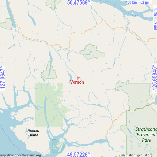
| Map corner | latitude | longitude |
|---|---|---|
| Upper-left | 50.47569°, | -127.0647° |
| Center: | 50.0261°, | -126.36157° |
| Lower-right: | 49.57226°, | -125.65845° |
| Map W x H: | 100.5×100.5 km | = 62.4×62.4mi |
| max Lat: | 73.03752° ⇑24.2% North |
| Vernon: | 50.0261° |
| min Lat: | ⇓75.8% South 42.05009° |
| min Long | Vernon | max Long |
| -139.43328° | -126.36157° | -52.70931° |
| W 1.6%⇐ | ⇒98.4% E |
Elevation
Elevation of Vernon is 259 m = 850 ft, and this is 4.6 m = 15 ft above average elevation for this country.
| Max E: |
1518 m = 4980 ft | 34.4% |
| Vernon | 259 m 850 ft | |
| Avg. | 254.4 m = 835 ft | |
Min E: |
-2 m = -7 ft | 65.6% |
See also: Vernon elevation on elevation.city.
Geographical zone
Vernon is located in North temperate zone (between Tropic of Cancer and the Arctic Circle). Distance of this North polar circle is 1838.8 km =1142.6 mi to North.| Distance of | km | miles | from Vernon |
|---|---|---|---|
| North Pole | 4444.7 | 2761.8 | to North |
| Arctic Circle | 1838.8 | 1142.6 | to North |
| Tropic Cancer | 2956.5 | 1837.1 | to South |
| Equator | 5562.4 | 3456.3 | to South |


Nearby cities:
15 places around Vernon: (largest is in red/bold)
• Campbell River
79.8 km =49.6 mi,  90°
90°
• Coombs
161.4 km =100.3 mi,  120°
120°
• Courtenay
105.1 km =65.3 mi,  111°
111°
• Cumberland
105.4 km =65.5 mi, 115°
• Dashwood
151.4 km =94.1 mi, 118°
• Denman Island
123.5 km =76.7 mi, 116°
• Denman Island Trust Area
124 km =77.1 mi, 115°
• Hornby Island
133.2 km =82.8 mi, 114°
• Port Alberni
142.2 km =88.4 mi,  127°
127°
• Port McNeill
80.6 km =50.1 mi,  320°
320°
• Powell River
133.3 km =82.8 mi,  99°
99°
• Puntledge
101.9 km =63.3 mi, 113°
• Royston
109.9 km =68.3 mi, 112°
• Tofino
102.4 km =63.6 mi,  161°
161°
• Ucluelet
134.2 km =83.4 mi,  153°
153°
Sources, notices
• [Note1] Compared only with cities in Canada existing in our database
• [Src1] Map data: © OpenStreetMap contributors (CC-BY-SA)
• [Src2] Other city data from geonames.org with taken over terms of usage.
• [Src3] Geographical zone / Annual Mean Temperature by Robert A. Rohde @ Wikipedia
