High Prairie geodata
High Prairie (Alberta) is a populated place; located in Canada in America/Edmonton (GMT-6) time zone. With population of 2,878 people, there are 630 cities with bigger population in this country. Compared to other cities in Canada, 96.2% of cities are located further ↓South; 84.3% of cities are located further →East and 86.3% of cities have lower elevation than High Prairie. Note1


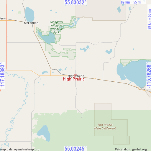
High Prairie GPS coordinates[2]
55° 26' 0.24" North, 116° 29' 8.88" West
| Map corner | latitude | longitude |
|---|---|---|
| Upper-left | 55.83032°, | -117.18893° |
| Center: | 55.4334°, | -116.4858° |
| Lower-right: | 55.03245°, | -115.78268° |
| Map W x H: | 88.7×88.7 km | = 55.1×55.1mi |
| max Lat: | 73.03752° ⇑3.8% North |
| High Prairie: | 55.4334° |
| min Lat: | ⇓96.2% South 42.05009° |
| min Long | High Prairie | max Long |
| -139.43328° | -116.4858° | -52.70931° |
| W 15.7%⇐ | ⇒84.3% E |
Elevation
Elevation of High Prairie is 593 m = 1946 ft, and this is 338.6 m = 1111 ft above average elevation for this country.
| Max E: |
1518 m = 4980 ft | 13.7% |
| High Prairie | 593 m 1946 ft | |
| Avg. | 254.4 m = 835 ft | |
Min E: |
-2 m = -7 ft | 86.3% |
See also: Canada elevation on elevation.city.
Geographical zone
High Prairie is located in North temperate zone (between Tropic of Cancer and the Arctic Circle). Distance of this North polar circle is 1237.6 km =769 mi to North.| Distance of | km | miles | from High Prairie |
|---|---|---|---|
| North Pole | 3843.4 | 2388.2 | to North |
| Arctic Circle | 1237.6 | 769 | to North |
| Tropic Cancer | 3557.7 | 2210.7 | to South |
| Equator | 6163.6 | 3829.9 | to South |


Nearby cities:
15 places around High Prairie: (largest is in red/bold)
• Fairview
138.2 km =85.9 mi,  300°
300°
• Falher
56.1 km =34.9 mi,  306°
306°
• Fox Creek
116.7 km =72.5 mi,  189°
189°
• Grande Prairie
149.6 km =93 mi,  258°
258°
• Grimshaw
108.7 km =67.5 mi,  320°
320°
• Peace River
102.6 km =63.8 mi,  330°
330°
• Sexsmith
145.6 km =90.5 mi,  266°
266°
• Slave Lake
109.8 km =68.2 mi,  98°
98°
• Spirit River
152.6 km =94.8 mi,  284°
284°
• Swan Hills
105.4 km =65.5 mi,  139°
139°
• Valleyview
65.1 km =40.5 mi,  231°
231°
• Wedgewood
148.9 km =92.5 mi, 256°
• Wembley
170.7 km =106.1 mi, 259°
• Westlake
148.5 km =92.3 mi, 260°
• Whitecourt
151.6 km =94.2 mi,  160°
160°
Sources, notices
• [Note1] Compared only with cities in Canada existing in our database
• [Src1] Map data: © OpenStreetMap contributors (CC-BY-SA)
• [Src2] Other city data from geonames.org with taken over terms of usage.
• [Src3] Geographical zone / Annual Mean Temperature by Robert A. Rohde @ Wikipedia
