Sparwood geodata
Sparwood (British Columbia) is a populated place; located in Canada in America/Edmonton (GMT-6) time zone. With population of 3,490 people, there are 571 cities with bigger population in this country. Compared to other cities in Canada, 73% of cities are located further ↓South; 82.8% of cities are located further →East and 99.3% of cities have lower elevation than Sparwood. Note1
Administrative division(s):
- Level 1: British Columbia
- Level 2: Regional District of East Kootenay
- Level 3: Sparwood


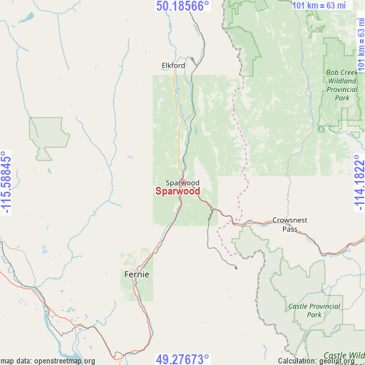
Sparwood GPS coordinates[2]
49° 43' 59.952" North, 114° 53' 7.152" West
| Map corner | latitude | longitude |
|---|---|---|
| Upper-left | 50.18566°, | -115.58845° |
| Center: | 49.73332°, | -114.88532° |
| Lower-right: | 49.27673°, | -114.1822° |
| Map W x H: | 101.1×101.1 km | = 62.8×62.8mi |
| max Lat: | 73.03752° ⇑27% North |
| Sparwood: | 49.73332° |
| min Lat: | ⇓73% South 42.05009° |
| min Long | Sparwood | max Long |
| -139.43328° | -114.88532° | -52.70931° |
| W 17.2%⇐ | ⇒82.8% E |
Elevation
Elevation of Sparwood is 1140 m = 3740 ft, and this is 885.6 m = 2906 ft above average elevation for this country.
| Max E: |
1518 m = 4980 ft | 0.7% |
| Sparwood | 1140 m 3740 ft | |
| Avg. | 254.4 m = 835 ft | |
Min E: |
-2 m = -7 ft | 99.3% |
See also: Canada elevation on elevation.city.
Geographical zone
Sparwood is located in North temperate zone (between Tropic of Cancer and the Arctic Circle). Distance of this North polar circle is 1871.3 km =1162.8 mi to North.| Distance of | km | miles | from Sparwood |
|---|---|---|---|
| North Pole | 4477.2 | 2782 | to North |
| Arctic Circle | 1871.3 | 1162.8 | to North |
| Tropic Cancer | 2923.9 | 1816.8 | to South |
| Equator | 5529.8 | 3436.1 | to South |


Nearby cities:
15 places around Sparwood: (largest is in red/bold)
• Black Diamond
117 km =72.7 mi,  23°
23°
• Cardston
128.9 km =80.1 mi,  117°
117°
• Claresholm
98.9 km =61.5 mi,  70°
70°
• Cranbrook
68.7 km =42.7 mi,  247°
247°
• Elkford
35.2 km =21.9 mi,  359°
359°
• Fernie
29.1 km =18.1 mi,  206°
206°
• Fort Macleod
105.4 km =65.5 mi,  91°
91°
• High River
119.1 km =74 mi,  37°
37°
• Invermere
119.6 km =74.3 mi,  316°
316°
• Jaffray
49.2 km =30.6 mi,  217°
217°
• Kimberley
78.9 km =49 mi,  264°
264°
• Nanton
105.2 km =65.4 mi,  49°
49°
• Okotoks
128 km =79.5 mi,  30°
30°
• Pincher Creek
72.8 km =45.2 mi,  112°
112°
• Wynndel
135.3 km =84.1 mi,  242°
242°
Sources, notices
• [Note1] Compared only with cities in Canada existing in our database
• [Src1] Map data: © OpenStreetMap contributors (CC-BY-SA)
• [Src2] Other city data from geonames.org with taken over terms of usage.
• [Src3] Geographical zone / Annual Mean Temperature by Robert A. Rohde @ Wikipedia
