Wynndel geodata
Wynndel (British Columbia) is a populated place; located in Canada in America/Creston (GMT-7) time zone. With population of 900 people, there are 1075 cities with bigger population in this country. Compared to other cities in Canada, 65.3% of cities are located further ↓South; 84.5% of cities are located further →East and 85.4% of cities have lower elevation than Wynndel. Note1


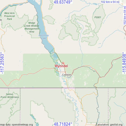
Wynndel GPS coordinates[2]
49° 10' 48" North, 116° 33' 9" West
| Map corner | latitude | longitude |
|---|---|---|
| Upper-left | 49.63749°, | -117.25563° |
| Center: | 49.18°, | -116.5525° |
| Lower-right: | 48.71824°, | -115.84938° |
| Map W x H: | 102.2×102.2 km | = 63.5×63.5mi |
| max Lat: | 73.03752° ⇑34.7% North |
| Wynndel: | 49.18° |
| min Lat: | ⇓65.3% South 42.05009° |
| min Long | Wynndel | max Long |
| -139.43328° | -116.5525° | -52.70931° |
| W 15.5%⇐ | ⇒84.5% E |
Elevation
Elevation of Wynndel is 578 m = 1896 ft, and this is 323.6 m = 1062 ft above average elevation for this country.
| Max E: |
1518 m = 4980 ft | 14.6% |
| Wynndel | 578 m 1896 ft | |
| Avg. | 254.4 m = 835 ft | |
Min E: |
-2 m = -7 ft | 85.4% |
See also: Canada elevation on elevation.city.
Geographical zone
Wynndel is located in North temperate zone (between Tropic of Cancer and the Arctic Circle). Distance of this North polar circle is 1932.9 km =1201 mi to North.| Distance of | km | miles | from Wynndel |
|---|---|---|---|
| North Pole | 4538.8 | 2820.3 | to North |
| Arctic Circle | 1932.9 | 1201 | to North |
| Tropic Cancer | 2862.4 | 1778.6 | to South |
| Equator | 5468.3 | 3397.8 | to South |


Nearby cities:
15 places around Wynndel: (largest is in red/bold)
• Castlegar
81.8 km =50.8 mi,  281°
281°
• Cranbrook
67 km =41.6 mi,  57°
57°
• Creston
9.6 km =6 mi,  157°
157°
• Fernie
113.2 km =70.3 mi,  71°
71°
• Fruitvale
73.1 km =45.4 mi,  264°
264°
• Grand Forks
138 km =85.7 mi, 263°
• Jaffray
93.5 km =58.1 mi,  76°
76°
• Kimberley
68.6 km =42.6 mi,  37°
37°
• Nakusp
149.1 km =92.6 mi,  322°
322°
• Nelson
63.9 km =39.7 mi,  303°
303°
• Rossland
91.6 km =56.9 mi, 263°
• Salmo
52.1 km =32.4 mi,  272°
272°
• Sion
142.4 km =88.5 mi, 262°
• Sparwood
135.3 km =84.1 mi, 62°
• Trail
84.1 km =52.3 mi, 263°
Sources, notices
• [Note1] Compared only with cities in Canada existing in our database
• [Src1] Map data: © OpenStreetMap contributors (CC-BY-SA)
• [Src2] Other city data from geonames.org with taken over terms of usage.
• [Src3] Geographical zone / Annual Mean Temperature by Robert A. Rohde @ Wikipedia
