Cardston geodata
Cardston (Alberta) is a populated place; located in Canada in America/Edmonton (GMT-6) time zone. With population of 3,654 people, there are 557 cities with bigger population in this country. Compared to other cities in Canada, 66% of cities are located further ↓South; 78.2% of cities are located further →East and 99.1% of cities have lower elevation than Cardston. Note1


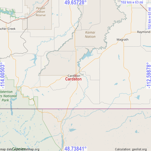
Cardston GPS coordinates[2]
49° 11' 59.928" North, 113° 18' 6.84" West
| Map corner | latitude | longitude |
|---|---|---|
| Upper-left | 49.65728°, | -114.00503° |
| Center: | 49.19998°, | -113.3019° |
| Lower-right: | 48.73841°, | -112.59878° |
| Map W x H: | 102.2×102.2 km | = 63.5×63.5mi |
| max Lat: | 73.03752° ⇑34% North |
| Cardston: | 49.19998° |
| min Lat: | ⇓66% South 42.05009° |
| min Long | Cardston | max Long |
| -139.43328° | -113.3019° | -52.70931° |
| W 21.8%⇐ | ⇒78.2% E |
Elevation
Elevation of Cardston is 1136 m = 3727 ft, and this is 881.6 m = 2892 ft above average elevation for this country.
| Max E: |
1518 m = 4980 ft | 0.90000000000001% |
| Cardston | 1136 m 3727 ft | |
| Avg. | 254.4 m = 835 ft | |
Min E: |
-2 m = -7 ft | 99.1% |
See also: Canada elevation on elevation.city.
Geographical zone
Cardston is located in North temperate zone (between Tropic of Cancer and the Arctic Circle). Distance of this North polar circle is 1930.6 km =1199.6 mi to North.| Distance of | km | miles | from Cardston |
|---|---|---|---|
| North Pole | 4536.5 | 2818.8 | to North |
| Arctic Circle | 1930.6 | 1199.6 | to North |
| Tropic Cancer | 2864.6 | 1780 | to South |
| Equator | 5470.5 | 3399.2 | to South |


Nearby cities:
15 places around Cardston: (largest is in red/bold)
• Claresholm
94.9 km =59 mi,  347°
347°
• Coaldale
75.8 km =47.1 mi,  40°
40°
• Coalhurst
66.4 km =41.3 mi,  23°
23°
• Fernie
132.2 km =82.1 mi,  284°
284°
• Fort Macleod
58.1 km =36.1 mi, 351°
• Lethbridge
65.7 km =40.8 mi,  32°
32°
• Magrath
39.6 km =24.6 mi,  52°
52°
• Nanton
132.2 km =82.1 mi, 345°
• Picture Butte
84.6 km =52.6 mi, 26°
• Pincher Creek
56.7 km =35.2 mi,  303°
303°
• Raymond
54.7 km =34 mi,  59°
59°
• Sparwood
128.9 km =80.1 mi, 297°
• Taber
106 km =65.9 mi, 51°
• Vauxhall
128.6 km =79.9 mi, 41°
• Vulcan
133.5 km =83 mi,  1°
1°
Sources, notices
• [Note1] Compared only with cities in Canada existing in our database
• [Src1] Map data: © OpenStreetMap contributors (CC-BY-SA)
• [Src2] Other city data from geonames.org with taken over terms of usage.
• [Src3] Geographical zone / Annual Mean Temperature by Robert A. Rohde @ Wikipedia
