Cranbrook geodata
Cranbrook (British Columbia) is a populated place; located in Canada in America/Edmonton (GMT-6) time zone. With population of 18,610 people, there are 199 cities with bigger population in this country. Compared to other cities in Canada, 70.3% of cities are located further ↓South; 83.8% of cities are located further →East and 96.7% of cities have lower elevation than Cranbrook. Note1
Administrative division(s):
- Level 1: British Columbia
- Level 2: Regional District of East Kootenay
- Level 3: Cranbrook


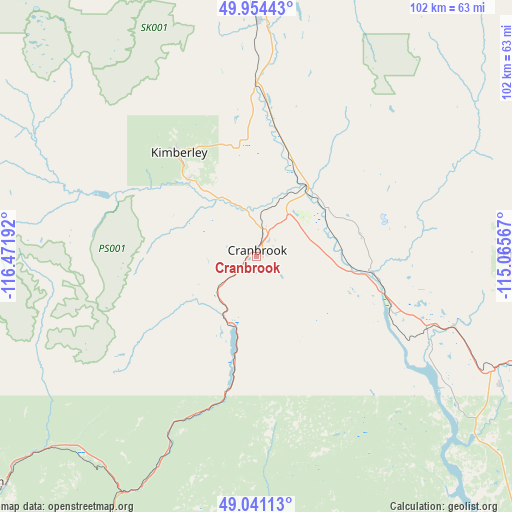
Cranbrook GPS coordinates[2]
49° 29' 59.676" North, 115° 46' 7.644" West
| Map corner | latitude | longitude |
|---|---|---|
| Upper-left | 49.95443°, | -116.47192° |
| Center: | 49.49991°, | -115.76879° |
| Lower-right: | 49.04113°, | -115.06567° |
| Map W x H: | 101.5×101.5 km | = 63.1×63.1mi |
| max Lat: | 73.03752° ⇑29.7% North |
| Cranbrook: | 49.49991° |
| min Lat: | ⇓70.3% South 42.05009° |
| min Long | Cranbrook | max Long |
| -139.43328° | -115.76879° | -52.70931° |
| W 16.2%⇐ | ⇒83.8% E |
Elevation
Elevation of Cranbrook is 949 m = 3114 ft, and this is 694.6 m = 2279 ft above average elevation for this country.
| Max E: |
1518 m = 4980 ft | 3.3% |
| Cranbrook | 949 m 3114 ft | |
| Avg. | 254.4 m = 835 ft | |
Min E: |
-2 m = -7 ft | 96.7% |
See also: Canada elevation on elevation.city.
Geographical zone
Cranbrook is located in North temperate zone (between Tropic of Cancer and the Arctic Circle). Distance of this North polar circle is 1897.3 km =1178.9 mi to North.| Distance of | km | miles | from Cranbrook |
|---|---|---|---|
| North Pole | 4503.2 | 2798.2 | to North |
| Arctic Circle | 1897.3 | 1178.9 | to North |
| Tropic Cancer | 2898 | 1800.7 | to South |
| Equator | 5503.9 | 3420 | to South |


Nearby cities:
15 places around Cranbrook: (largest is in red/bold)
• Castlegar
138.1 km =85.8 mi,  261°
261°
• Creston
69.3 km =43.1 mi,  230°
230°
• Elkford
88.1 km =54.7 mi,  46°
46°
• Fernie
50.6 km =31.4 mi,  89°
89°
• Fruitvale
136.1 km =84.6 mi,  251°
251°
• Invermere
114.6 km =71.2 mi,  350°
350°
• Jaffray
36.2 km =22.5 mi,  111°
111°
• Kimberley
24.2 km =15 mi,  321°
321°
• Nelson
109.5 km =68 mi,  269°
269°
• Pincher Creek
131.2 km =81.5 mi, 90°
• Rossland
154.6 km =96.1 mi, 252°
• Salmo
113.7 km =70.6 mi, 252°
• Sparwood
68.7 km =42.7 mi,  67°
67°
• Trail
147.1 km =91.4 mi, 252°
• Wynndel
67 km =41.6 mi,  237°
237°
Sources, notices
• [Note1] Compared only with cities in Canada existing in our database
• [Src1] Map data: © OpenStreetMap contributors (CC-BY-SA)
• [Src2] Other city data from geonames.org with taken over terms of usage.
• [Src3] Geographical zone / Annual Mean Temperature by Robert A. Rohde @ Wikipedia
