Pincher Creek geodata
Pincher Creek (Alberta) is a populated place; located in Canada in America/Edmonton (GMT-6) time zone. With population of 3,855 people, there are 544 cities with bigger population in this country. Compared to other cities in Canada, 70% of cities are located further ↓South; 81.2% of cities are located further →East and 99.5% of cities have lower elevation than Pincher Creek. Note1


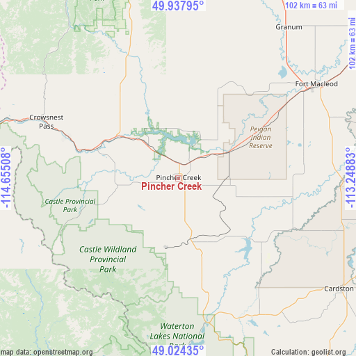
Pincher Creek GPS coordinates[2]
49° 28' 59.808" North, 113° 57' 7.02" West
| Map corner | latitude | longitude |
|---|---|---|
| Upper-left | 49.93795°, | -114.65508° |
| Center: | 49.48328°, | -113.95195° |
| Lower-right: | 49.02435°, | -113.24883° |
| Map W x H: | 101.6×101.6 km | = 63.1×63.1mi |
| max Lat: | 73.03752° ⇑30% North |
| Pincher Creek: | 49.48328° |
| min Lat: | ⇓70% South 42.05009° |
| min Long | Pincher Creek | max Long |
| -139.43328° | -113.95195° | -52.70931° |
| W 18.8%⇐ | ⇒81.2% E |
Elevation
Elevation of Pincher Creek is 1151 m = 3776 ft, and this is 896.6 m = 2942 ft above average elevation for this country.
| Max E: |
1518 m = 4980 ft | 0.5% |
| Pincher Creek | 1151 m 3776 ft | |
| Avg. | 254.4 m = 835 ft | |
Min E: |
-2 m = -7 ft | 99.5% |
See also: Canada elevation on elevation.city.
Geographical zone
Pincher Creek is located in North temperate zone (between Tropic of Cancer and the Arctic Circle). Distance of this North polar circle is 1899.1 km =1180 mi to North.| Distance of | km | miles | from Pincher Creek |
|---|---|---|---|
| North Pole | 4505 | 2799.3 | to North |
| Arctic Circle | 1899.1 | 1180 | to North |
| Tropic Cancer | 2896.1 | 1799.6 | to South |
| Equator | 5502 | 3418.8 | to South |


Nearby cities:
15 places around Pincher Creek: (largest is in red/bold)
• Cardston
56.7 km =35.2 mi,  123°
123°
• Claresholm
66.6 km =41.4 mi,  23°
23°
• Coaldale
99.5 km =61.8 mi,  74°
74°
• Coalhurst
79.1 km =49.2 mi, 68°
• Elkford
92 km =57.2 mi,  313°
313°
• Fernie
80.7 km =50.1 mi,  271°
271°
• Fort Macleod
46.4 km =28.8 mi,  55°
55°
• Jaffray
98.3 km =61.1 mi,  263°
263°
• Lethbridge
85.2 km =52.9 mi, 73°
• Magrath
78.7 km =48.9 mi,  95°
95°
• Nanton
97.3 km =60.5 mi,  7°
7°
• Picture Butte
95 km =59 mi, 62°
• Raymond
94 km =58.4 mi,  92°
92°
• Sparwood
72.8 km =45.2 mi,  292°
292°
• Vulcan
113.6 km =70.6 mi,  26°
26°
Sources, notices
• [Note1] Compared only with cities in Canada existing in our database
• [Src1] Map data: © OpenStreetMap contributors (CC-BY-SA)
• [Src2] Other city data from geonames.org with taken over terms of usage.
• [Src3] Geographical zone / Annual Mean Temperature by Robert A. Rohde @ Wikipedia
