Belmont geodata
Belmont (Ontario) is a populated place; located in Canada in America/Toronto (GMT-4) time zone. With population of 1,140 people, there are 980 cities with bigger population in this country. Compared to other cities in Canada, 98.4% of cities are located further ↑North; 59.3% of cities are located further →East and 65.2% of cities have lower elevation than Belmont. Note1


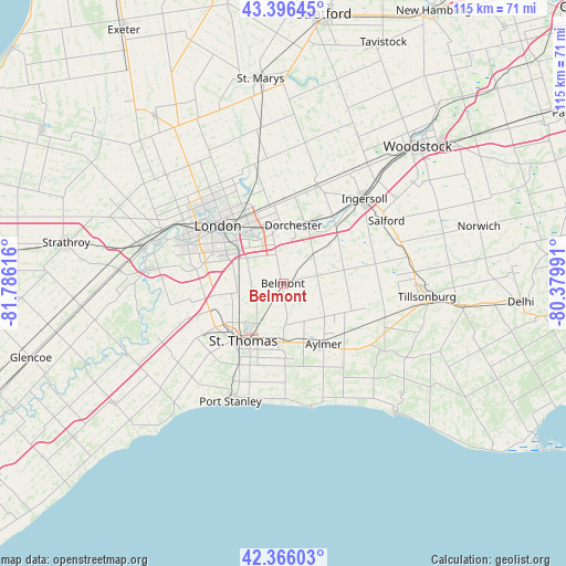
Belmont GPS coordinates[2]
42° 53' 0.204" North, 81° 4' 58.908" West
| Map corner | latitude | longitude |
|---|---|---|
| Upper-left | 43.39645°, | -81.78616° |
| Center: | 42.88339°, | -81.08303° |
| Lower-right: | 42.36603°, | -80.37991° |
| Map W x H: | 114.6×114.6 km | = 71.2×71.2mi |
| max Lat: | 73.03752° ⇑98.4% North |
| Belmont: | 42.88339° |
| min Lat: | ⇓1.6% South 42.05009° |
| min Long | Belmont | max Long |
| -139.43328° | -81.08303° | -52.70931° |
| W 40.7%⇐ | ⇒59.3% E |
Elevation
Elevation of Belmont is 257 m = 843 ft, and this is 2.6 m = 9 ft above average elevation for this country.
| Max E: |
1518 m = 4980 ft | 34.8% |
| Belmont | 257 m 843 ft | |
| Avg. | 254.4 m = 835 ft | |
Min E: |
-2 m = -7 ft | 65.2% |
See also: Canada elevation on elevation.city.
Geographical zone
Belmont is located in North temperate zone (between Tropic of Cancer and the Arctic Circle). Distance of this Northern Tropic circle is 2162.3 km =1343.6 mi to South.| Distance of | km | miles | from Belmont |
|---|---|---|---|
| North Pole | 5238.9 | 3255.3 | to North |
| Arctic Circle | 2633 | 1636.1 | to North |
| Tropic Cancer | 2162.3 | 1343.6 | to South |
| Equator | 4768.2 | 2962.8 | to South |


Nearby cities:
15 places around Belmont: (largest is in red/bold)
• Aylmer
15.3 km =9.5 mi,  147°
147°
• Delaware
27.4 km =17 mi,  277°
277°
• Dorchester
11.2 km =7 mi,  6°
6°
• Glencoe
53.7 km =33.4 mi,  253°
253°
• Ingersoll
23.3 km =14.5 mi,  44°
44°
• London
16.5 km =10.3 mi,  312°
312°
• Lucan
42.1 km =26.2 mi,  322°
322°
• Mount Brydges
32.6 km =20.3 mi,  273°
273°
• Norfolk County
57.3 km =35.6 mi,  95°
95°
• Port Stanley
26.4 km =16.4 mi,  204°
204°
• St. Thomas
14.6 km =9.1 mi,  213°
213°
• Stratford
54.8 km =34.1 mi, 11°
• Tavistock
52.3 km =32.5 mi,  22°
22°
• West Lorne
52.7 km =32.7 mi,  233°
233°
• Woodstock
38.8 km =24.1 mi, 44°
Sources, notices
• [Note1] Compared only with cities in Canada existing in our database
• [Src1] Map data: © OpenStreetMap contributors (CC-BY-SA)
• [Src2] Other city data from geonames.org with taken over terms of usage.
• [Src3] Geographical zone / Annual Mean Temperature by Robert A. Rohde @ Wikipedia
