Bumba geodata
Bumba (Mongala) is a populated place; located in Democratic Republic of the Congo in Africa/Kinshasa (GMT+1) time zone. With population of 95,520 people, there are 27 cities with bigger population in this country. Compared to other cities in Democratic Republic of the Congo, 85.7% of cities are located further ↓South; 52.9% of cities are located further →East and 77.1% of cities have higher elevation than Bumba. Note1


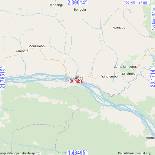
Bumba GPS coordinates[2]
2° 11' 15.756" North, 22° 28' 5.772" East
| Map corner | latitude | longitude |
|---|---|---|
| Upper-left | 2.89014°, | 21.76515° |
| Center: | 2.18771°, | 22.46827° |
| Lower-right: | 1.48495°, | 23.1714° |
| Map W x H: | 156.2×156.2 km | = 97.1×97.1mi |
| max Lat: | 4.279° ⇑14.3% North |
| Bumba: | 2.18771° |
| min Lat: | ⇓85.7% South -11.76097° |
| min Long | Bumba | max Long |
| 12.37148° | 22.46827° | 30.25224° |
| W 47.1%⇐ | ⇒52.9% E |
Elevation
Elevation of Bumba is 362 m = 1188 ft, and this is 294 m = 965 ft below average elevation for this country.
| Max E: |
1996 m = 6549 ft | 77.1% |
| Avg. | 656 m = 2152 ft | |
| Bumba | 362 m = 1188 ft | |
Min E: |
11 m = 36 ft | 22.9% |
See also: Bumba elevation on elevation.city.
Geographical zone
Bumba is located in North Torrid zone (between Equator and Tropic of Cancer). Distance of Equator is 243.3 km =151.2 mi to South.| Distance of | km | miles | from Bumba |
|---|---|---|---|
| North Pole | 9763.8 | 6066.9 | to North |
| Arctic Circle | 7157.9 | 4447.7 | to North |
| Tropic Cancer | 2362.7 | 1468.1 | to North |
| Equator | 243.3 | 151.2 | to South |


Nearby cities:
13 places around Bumba: (largest is in red/bold)
• Aketi
158.4 km =98.4 mi,  67°
67°
• Basoko
165.5 km =102.8 mi,  129°
129°
• Boende
326.4 km =202.8 mi,  212°
212°
• Bondo
225.9 km =140.4 mi,  36°
36°
• Bongandanga
172.6 km =107.2 mi,  243°
243°
• Bosobolo
363.2 km =225.7 mi,  307°
307°
• Businga
217.4 km =135.1 mi, 306°
• Buta
259.9 km =161.5 mi,  75°
75°
• Gbadolite
283.8 km =176.3 mi,  325°
325°
• Gemena
322.1 km =200.1 mi,  291°
291°
• Kisangani
355.2 km =220.7 mi,  121°
121°
• Lisala
105.8 km =65.7 mi,  267°
267°
• Yangambi
270.1 km =167.8 mi, 125°
Sources, notices
• [Note1] Compared only with cities in Democratic Republic of the Congo existing in our database
• [Src1] Map data: © OpenStreetMap contributors (CC-BY-SA)
• [Src2] Other city data from geonames.org with taken over terms of usage.
• [Src3] Geographical zone / Annual Mean Temperature by Robert A. Rohde @ Wikipedia
